Ville-sous-Anjou elevation
Ville-sous-Anjou (Auvergne-Rhône-Alpes, Département de l'Isère), France elevation is 238 meters and Ville-sous-Anjou elevation in feet is 781 ft above sea level [src 1]. Ville-sous-Anjou is a populated place (feature code) with elevation that is 64 meters (210 ft) bigger than average city elevation in France.
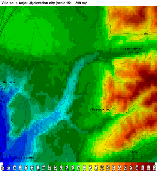
Below is the Elevation map of Ville-sous-Anjou, which displays elevation range with different colors. Scale of the first map is from 151 to 399 m (495 to 1309 ft) with average elevation of 256.6 meters (=842 ft) [note 1]
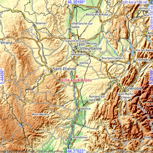
These maps also provides idea of topography and contour of this city, they are displayed at different zoom levels. More info about maps, scale and edge coordinates you can find below images.
| \ | Map #1 | Topo.Map |
| Scale [m] | 151..399 m | × |
| Scale [ft] | 495..1309 ft | × |
| Average | 256.6 m = 842 ft | × |
| Width | 6.87 km = 4.3 mi | 219.7 km = 136.5 mi |
| Height | 6.87 km = 4.3 mi | 219.7 km = 136.5 mi |
| ↑Max Latitude | 45.403603° | 46.35199° |
| Latitude at center | 45.37274° | 45.37274° |
| ↓Min Latitude | 45.34186° | 44.37623° |
| ← Min Longitude | 4.806865° | 3.44456° |
| Longitude center | 4.85081° | 4.85081° |
| →Max Longitude | 4.894755° | 6.25706° |
Nearby cities:
Cities around Ville-sous-Anjou sort by population:
• Roussillon elevation 219 m
2.8 km,  272°
272°
• Le Péage-de-Roussillon 170 m
4.2 km, 271°
• Salaise-sur-Sanne 187 m
3.9 km,  232°
232°
• Chanas 181 m
6.5 km,  202°
202°
• Sablons 136 m
8.3 km, 226°
• Auberives-sur-Varèze 239 m
5.9 km,  335°
335°
• Clonas-sur-Varèze 189 m
6.5 km,  314°
314°
• Saint-Pierre-de-Bœuf 222 m
7.9 km, 265°
• Épinouze 228 m
9.3 km,  138°
138°
• Serrières 142 m
9.2 km, 228°
• Vernioz 270 m
6.5 km,  22°
22°
• Sonnay 250 m
4.5 km,  111°
111°
Multilingual:
 En español:
Ville-sous-Anjou elevación 238 m.
 En France:
Ville-sous-Anjou élévation 238 m.
 Auf Deutsch:
Ville-sous-Anjou höhe über dem Meeresspiegel ist 238 m.

Sources and notes:
- [note 1] Map square and city borders are not equal. Map elevation data is calculated only from area inside that square.
- [src 1] Elevation data from geonames database provided with same terms of usage.
- [src 2] The elevation map of Ville-sous-Anjou is generated using elevation data from NASA's 3 arcsec (90m) resolution SRTM data.
- [src 3] Base (background) map © OpenStreetMap contributors tiles are generated by Geofabrik and OpenTopoMap.
Copyright & License:
This Ville-sous-Anjou Elevation Map is licensed under CC BY-SA. You may reuse any part from this page, if you give a proper credit by linking to this URL:
 More info on terms of use page.