Le Pont-de-Claix elevation
Le Pont-de-Claix (Auvergne-Rhône-Alpes, Département de l'Isère), France elevation is 246 meters and Le Pont-de-Claix elevation in feet is 807 ft above sea level [src 1]. Le Pont-de-Claix is a populated place (feature code) with elevation that is 72 meters (236 ft) bigger than average city elevation in France.
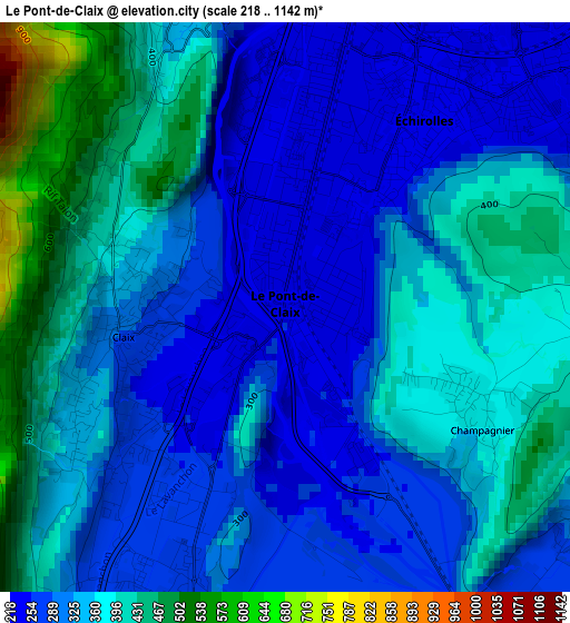
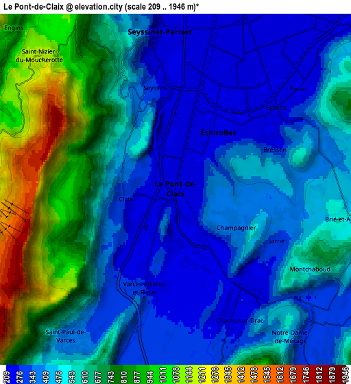
Below is the Elevation map of Le Pont-de-Claix, which displays elevation range with different colors. Scale of the first map is from 218 to 1142 m (715 to 3747 ft) with average elevation of 339.2 meters (=1113 ft) [note 1]
These maps also provides idea of topography and contour of this city, they are displayed at different zoom levels. More info about maps, scale and edge coordinates you can find below images.
| \ | Map #1 | Map #2 | Topo.Map |
| Scale [m] | 218..1142 m | 209..1946 m | × |
| Scale [ft] | 715..3747 ft | 686..6385 ft | × |
| Average | 339.2 m = 1113 ft | 549.3 m = 1802 ft | × |
| Width | 6.9 km = 4.3 mi | 13.79 km = 8.6 mi | 220.7 km = 137.1 mi |
| Height | 6.9 km = 4.3 mi | 13.79 km = 8.6 mi | 220.6 km = 137.1 mi |
| ↑Max Latitude | 45.154209° | 45.185191° | 46.10681° |
| Latitude at center | 45.12321° | 45.12321° | 45.12321° |
| ↓Min Latitude | 45.092194° | 45.061162° | 44.12235° |
| ← Min Longitude | 5.653875° | 5.609929° | 4.29157° |
| Longitude center | 5.69782° | 5.69782° | 5.69782° |
| →Max Longitude | 5.741765° | 5.785711° | 7.10407° |
Nearby cities:
Cities around Le Pont-de-Claix sort by population:
• Grenoble elevation 213 m
6.3 km,  12°
12°
• Échirolles 230 m
2.9 km,  27°
27°
• Seyssinet-Pariset 222 m
6 km,  357°
357°
• Eybens 320 m
4.9 km,  56°
56°
• Claix 263 m
2 km,  259°
259°
• Seyssins 226 m
4.4 km,  348°
348°
• Allières-et-Risset 262 m
3 km,  208°
208°
• Jarrie 394 m
4.9 km,  97°
97°
• Champ-sur-Drac 318 m
6.5 km,  156°
156°
• Poisat 281 m
6.3 km,  51°
51°
• Brié-et-Angonnes 442 m
6.7 km,  89°
89°
• Champagnier 411 m
2.6 km,  119°
119°
Multilingual:
 En español:
Le Pont-de-Claix elevación 246 m.
 En France:
Le Pont-de-Claix élévation 246 m.
 Auf Deutsch:
Le Pont-de-Claix höhe über dem Meeresspiegel ist 246 m.

Sources and notes:
- [note 1] Map square and city borders are not equal. Map elevation data is calculated only from area inside that square.
- [src 1] Elevation data from geonames database provided with same terms of usage.
- [src 2] The elevation map of Le Pont-de-Claix is generated using elevation data from NASA's 3 arcsec (90m) resolution SRTM data.
- [src 3] Base (background) map © OpenStreetMap contributors tiles are generated by Geofabrik and OpenTopoMap.
Copyright & License:
This Le Pont-de-Claix Elevation Map is licensed under CC BY-SA. You may reuse any part from this page, if you give a proper credit by linking to this URL:
 More info on terms of use page.