Les Échelles elevation
Les Échelles (Auvergne-Rhône-Alpes, Savoie), France elevation is 387 meters and Les Échelles elevation in feet is 1270 ft above sea level [src 1]. Les Échelles is a populated place (feature code) with elevation that is 213 meters (699 ft) bigger than average city elevation in France.
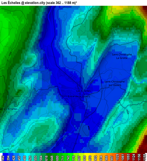
Below is the Elevation map of Les Échelles, which displays elevation range with different colors. Scale of the first map is from 362 to 1188 m (1188 to 3898 ft) with average elevation of 513.6 meters (=1685 ft) [note 1]
These maps also provides idea of topography and contour of this city, they are displayed at different zoom levels. More info about maps, scale and edge coordinates you can find below images.
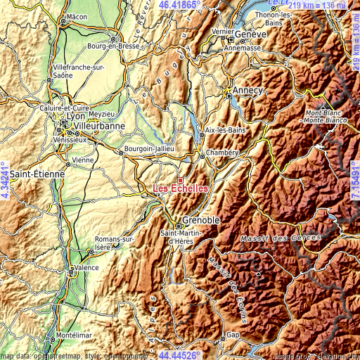
| \ | Map #1 | Topo.Map |
| Scale [m] | 362..1188 m | × |
| Scale [ft] | 1188..3898 ft | × |
| Average | 513.6 m = 1685 ft | × |
| Width | 6.86 km = 4.3 mi | 219.4 km = 136.3 mi |
| Height | 6.86 km = 4.3 mi | 219.4 km = 136.3 mi |
| ↑Max Latitude | 45.471406° | 46.41865° |
| Latitude at center | 45.44058° | 45.44058° |
| ↓Min Latitude | 45.409737° | 44.44526° |
| ← Min Longitude | 5.704715° | 4.34241° |
| Longitude center | 5.74866° | 5.74866° |
| →Max Longitude | 5.792605° | 7.15491° |
Nearby cities:
Cities around Les Échelles sort by population:
• Saint-Laurent-du-Pont elevation 394 m
5.5 km,  192°
192°
• Le Pont-de-Beauvoisin 258 m
12.2 km,  331°
331°
• Saint-Étienne-de-Crossey 450 m
10.6 km,  230°
230°
• Saint-Geoire-en-Valdaine 454 m
9 km,  281°
281°
• Miribel-les-Échelles 521 m
3.3 km,  252°
252°
• Entre-Deux-Guiers 393 m
1.1 km,  166°
166°
• Domessin 297 m
12.4 km,  343°
343°
• Montferrat 564 m
13.3 km,  291°
291°
• Saint-Béron 372 m
7.1 km,  346°
346°
• La Bridoire 268 m
9.4 km,  356°
356°
• Saint-Joseph-de-Rivière 419 m
8.3 km,  209°
209°
• Saint-Aupre 614 m
7.6 km,  236°
236°
Multilingual:
 En español:
Les Échelles elevación 387 m.
 En France:
Les Échelles élévation 387 m.
 Auf Deutsch:
Les Échelles höhe über dem Meeresspiegel ist 387 m.

Sources and notes:
- [note 1] Map square and city borders are not equal. Map elevation data is calculated only from area inside that square.
- [src 1] Elevation data from geonames database provided with same terms of usage.
- [src 2] The elevation map of Les Échelles is generated using elevation data from NASA's 3 arcsec (90m) resolution SRTM data.
- [src 3] Base (background) map © OpenStreetMap contributors tiles are generated by Geofabrik and OpenTopoMap.
Copyright & License:
This Les Échelles Elevation Map is licensed under CC BY-SA. You may reuse any part from this page, if you give a proper credit by linking to this URL:
 More info on terms of use page.