Les Roches-de-Condrieu elevation
Les Roches-de-Condrieu (Auvergne-Rhône-Alpes, Département de l'Isère), France elevation is 163 meters and Les Roches-de-Condrieu elevation in feet is 535 ft above sea level [src 1]. Les Roches-de-Condrieu is a populated place (feature code) with elevation that is 11 meters (36 ft) smaller than average city elevation in France.
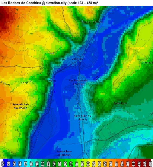
Below is the Elevation map of Les Roches-de-Condrieu, which displays elevation range with different colors. Scale of the first map is from 123 to 458 m (404 to 1503 ft) with average elevation of 238 meters (=781 ft) [note 1]
These maps also provides idea of topography and contour of this city, they are displayed at different zoom levels. More info about maps, scale and edge coordinates you can find below images.
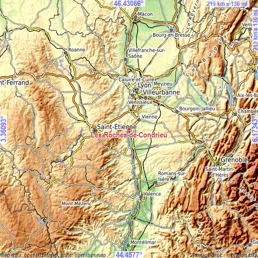
| \ | Map #1 | Topo.Map |
| Scale [m] | 123..458 m | × |
| Scale [ft] | 404..1503 ft | × |
| Average | 238 m = 781 ft | × |
| Width | 6.86 km = 4.3 mi | 219.4 km = 136.3 mi |
| Height | 6.86 km = 4.3 mi | 219.4 km = 136.3 mi |
| ↑Max Latitude | 45.483629° | 46.43066° |
| Latitude at center | 45.45281° | 45.45281° |
| ↓Min Latitude | 45.421974° | 44.4577° |
| ← Min Longitude | 4.723235° | 3.36093° |
| Longitude center | 4.76718° | 4.76718° |
| →Max Longitude | 4.811125° | 6.17343° |
Nearby cities:
Cities around Les Roches-de-Condrieu sort by population:
• Roussillon elevation 219 m
9.5 km,  156°
156°
• Le Péage-de-Roussillon 170 m
9.1 km,  165°
165°
• Saint-Clair-du-Rhône 249 m
1.3 km, 165°
• Condrieu 153 m
1.1 km,  1°
1°
• Pélussin 363 m
7.5 km,  240°
240°
• Chavanay 147 m
5.2 km,  218°
218°
• Ampuis 155 m
5.3 km,  39°
39°
• Les Côtes-d'Arey 303 m
7.8 km,  87°
87°
• Reventin-Vaugris 303 m
6.1 km,  75°
75°
• Auberives-sur-Varèze 239 m
5.4 km,  131°
131°
• Clonas-sur-Varèze 189 m
4.7 km, 156°
• Vernioz 270 m
9.5 km,  107°
107°
Multilingual:
 En español:
Les Roches-de-Condrieu elevación 163 m.
 En France:
Les Roches-de-Condrieu élévation 163 m.
 Auf Deutsch:
Les Roches-de-Condrieu höhe über dem Meeresspiegel ist 163 m.
 На русском:
Les Roches-de-Condrieu высота над уровнем моря 163 м
Sources and notes:
- [note 1] Map square and city borders are not equal. Map elevation data is calculated only from area inside that square.
- [src 1] Elevation data from geonames database provided with same terms of usage.
- [src 2] The elevation map of Les Roches-de-Condrieu is generated using elevation data from NASA's 3 arcsec (90m) resolution SRTM data.
- [src 3] Base (background) map © OpenStreetMap contributors tiles are generated by Geofabrik and OpenTopoMap.
Copyright & License:
This Les Roches-de-Condrieu Elevation Map is licensed under CC BY-SA. You may reuse any part from this page, if you give a proper credit by linking to this URL:
 More info on terms of use page.