Lézignan-Corbières elevation
Lézignan-Corbières (Occitanie, Département de l'Aude), France elevation is 49 meters and Lézignan-Corbières elevation in feet is 161 ft above sea level [src 1]. Lézignan-Corbières is a populated place (feature code) with elevation that is 125 meters (410 ft) smaller than average city elevation in France.
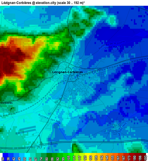
Below is the Elevation map of Lézignan-Corbières, which displays elevation range with different colors. Scale of the first map is from 30 to 192 m (98 to 630 ft) with average elevation of 62 meters (=203 ft) [note 1]
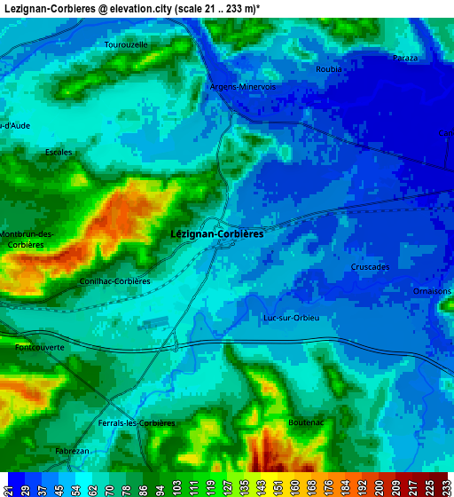
These maps also provides idea of topography and contour of this city, they are displayed at different zoom levels. More info about maps, scale and edge coordinates you can find below images.
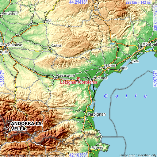
| \ | Map #1 | Map #2 | Topo.Map |
| Scale [m] | 30..192 m | 21..233 m | × |
| Scale [ft] | 98..630 ft | 69..764 ft | × |
| Average | 62 m = 203 ft | 67.4 m = 221 ft | × |
| Width | 7.12 km = 4.4 mi | 14.25 km = 8.9 mi | 228 km = 141.7 mi |
| Height | 7.12 km = 4.4 mi | 14.25 km = 8.9 mi | 228 km = 141.7 mi |
| ↑Max Latitude | 43.229678° | 43.261688° | 44.21418° |
| Latitude at center | 43.19765° | 43.19765° | 43.19765° |
| ↓Min Latitude | 43.165606° | 43.133544° | 42.16389° |
| ← Min Longitude | 2.717475° | 2.673529° | 1.35517° |
| Longitude center | 2.76142° | 2.76142° | 2.76142° |
| →Max Longitude | 2.805365° | 2.849311° | 4.16767° |
Nearby cities:
Cities around Lézignan-Corbières sort by population:
• Saint-Nazaire-d’Aude elevation 26 m
12 km,  63°
63°
• Canet 27 m
7.8 km, 64°
• Olonzac 53 m
9.8 km,  345°
345°
• Fabrezan 79 m
8.6 km,  216°
216°
• Névian 29 m
11.6 km,  81°
81°
• Bizanet 58 m
9.6 km,  112°
112°
• Ornaisons 41 m
6.4 km, 107°
• Ginestas 69 m
11.7 km,  49°
49°
• Puicheric 64 m
11.5 km,  284°
284°
• Azille 90 m
12.1 km,  316°
316°
• Pépieux 89 m
12.9 km,  329°
329°
• Ferrals-les-Corbières 68 m
5.8 km,  203°
203°
Multilingual:
 En español:
Lézignan-Corbières elevación 49 m.
 En France:
Lézignan-Corbières élévation 49 m.
 Auf Deutsch:
Lézignan-Corbières höhe über dem Meeresspiegel ist 49 m.

Sources and notes:
- [note 1] Map square and city borders are not equal. Map elevation data is calculated only from area inside that square.
- [src 1] Elevation data from geonames database provided with same terms of usage.
- [src 2] The elevation map of Lézignan-Corbières is generated using elevation data from NASA's 3 arcsec (90m) resolution SRTM data.
- [src 3] Base (background) map © OpenStreetMap contributors tiles are generated by Geofabrik and OpenTopoMap.
Copyright & License:
This Lézignan-Corbières Elevation Map is licensed under CC BY-SA. You may reuse any part from this page, if you give a proper credit by linking to this URL:
 More info on terms of use page.