Limoux elevation
Limoux (Occitanie, Département de l'Aude), France elevation is 172 meters and Limoux elevation in feet is 564 ft above sea level [src 1]. Limoux is a seat of a third-order administrative division (feature code) with elevation that is 2 meters (7 ft) smaller than average city elevation in France.
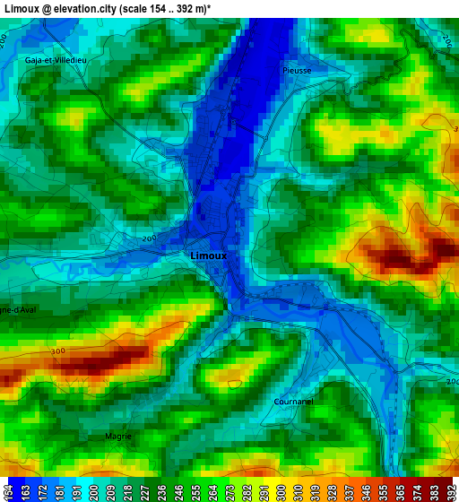
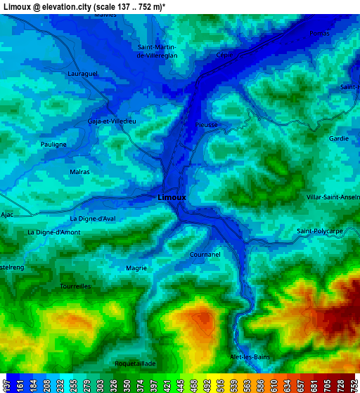
Below is the Elevation map of Limoux, which displays elevation range with different colors. Scale of the first map is from 154 to 392 m (505 to 1286 ft) with average elevation of 232.9 meters (=764 ft) [note 1]
These maps also provides idea of topography and contour of this city, they are displayed at different zoom levels. More info about maps, scale and edge coordinates you can find below images.
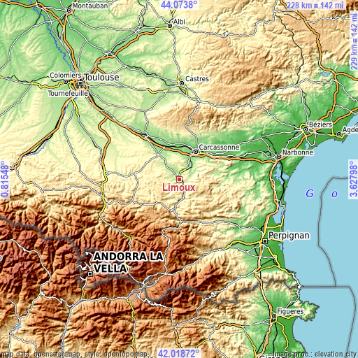
| \ | Map #1 | Map #2 | Topo.Map |
| Scale [m] | 154..392 m | 137..752 m | × |
| Scale [ft] | 505..1286 ft | 449..2467 ft | × |
| Average | 232.9 m = 764 ft | 284.6 m = 934 ft | × |
| Width | 7.14 km = 4.4 mi | 14.28 km = 8.9 mi | 228.5 km = 142 mi |
| Height | 7.14 km = 4.4 mi | 14.28 km = 8.9 mi | 228.5 km = 142 mi |
| ↑Max Latitude | 43.086972° | 43.119058° | 44.0738° |
| Latitude at center | 43.05487° | 43.05487° | 43.05487° |
| ↓Min Latitude | 43.022751° | 42.990615° | 42.01872° |
| ← Min Longitude | 2.177785° | 2.133839° | 0.81548° |
| Longitude center | 2.22173° | 2.22173° | 2.22173° |
| →Max Longitude | 2.265675° | 2.309621° | 3.62798° |
Nearby cities:
Cities around Limoux sort by population:
• Carcassonne elevation 103 m
20.5 km,  30°
30°
• Quillan 291 m
20.2 km,  189°
189°
• Espéraza 249 m
13.6 km,  180°
180°
• Palaja 178 m
18.7 km,  45°
45°
• Montréal 260 m
17.4 km,  337°
337°
• Cazilhac 140 m
18.1 km,  38°
38°
• Pezens 122 m
22.5 km,  9°
9°
• Alzonne 125 m
22.4 km,  350°
350°
• Couiza 230 m
12.8 km,  168°
168°
• Chalabre 375 m
19.3 km,  245°
245°
• Lavalette 187 m
14.9 km, 14°
• Arzens 198 m
16 km,  356°
356°
Multilingual:
 En español:
Limoux elevación 172 m.
 En France:
Limoux élévation 172 m.


Sources and notes:
- [note 1] Map square and city borders are not equal. Map elevation data is calculated only from area inside that square.
- [src 1] Elevation data from geonames database provided with same terms of usage.
- [src 2] The elevation map of Limoux is generated using elevation data from NASA's 3 arcsec (90m) resolution SRTM data.
- [src 3] Base (background) map © OpenStreetMap contributors tiles are generated by Geofabrik and OpenTopoMap.
Copyright & License:
This Limoux Elevation Map is licensed under CC BY-SA. You may reuse any part from this page, if you give a proper credit by linking to this URL:
 More info on terms of use page.