Longuyon elevation
Longuyon (Grand Est, Meurthe-et-Moselle), France elevation is 298 meters and Longuyon elevation in feet is 978 ft above sea level [src 1]. Longuyon is a populated place (feature code) with elevation that is 124 meters (407 ft) bigger than average city elevation in France.
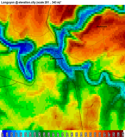
Below is the Elevation map of Longuyon, which displays elevation range with different colors. Scale of the first map is from 201 to 343 m (659 to 1125 ft) with average elevation of 276.5 meters (=907 ft) [note 1]
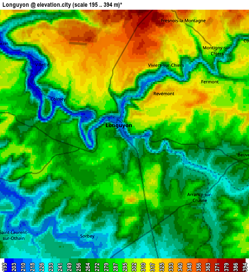
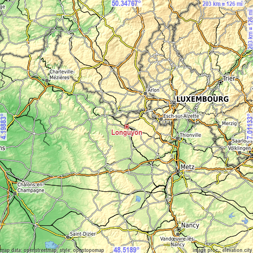
These maps also provides idea of topography and contour of this city, they are displayed at different zoom levels. More info about maps, scale and edge coordinates you can find below images.
| \ | Map #1 | Map #2 | Topo.Map |
| Scale [m] | 201..343 m | 195..394 m | × |
| Scale [ft] | 659..1125 ft | 640..1293 ft | × |
| Average | 276.5 m = 907 ft | 278.3 m = 913 ft | × |
| Width | 6.35 km = 3.9 mi | 12.71 km = 7.9 mi | 203.3 km = 126.3 mi |
| Height | 6.35 km = 3.9 mi | 12.71 km = 7.9 mi | 203.3 km = 126.3 mi |
| ↑Max Latitude | 49.470376° | 49.498925° | 50.34767° |
| Latitude at center | 49.44181° | 49.44181° | 49.44181° |
| ↓Min Latitude | 49.413228° | 49.384628° | 48.5189° |
| ← Min Longitude | 5.561135° | 5.517189° | 4.19883° |
| Longitude center | 5.60508° | 5.60508° | 5.60508° |
| →Max Longitude | 5.649025° | 5.692971° | 7.01133° |
Nearby cities:
Cities around Longuyon sort by population:
• Longwy elevation 270 m
14.4 km,  51°
51°
• Mont-Saint-Martin 277 m
17.1 km, 48°
• Herserange 270 m
16 km,  56°
56°
• Réhon 357 m
12.5 km, 59°
• Lexy 283 m
11.1 km, 54°
• Haucourt 377 m
15.3 km,  69°
69°
• Gorcy 310 m
11.8 km,  29°
29°
• Cosnes 378 m
11.6 km,  41°
41°
• Mexy 375 m
14.3 km, 62°
• Villers-la-Montagne 390 m
16.3 km,  78°
78°
• Mercy-le-Bas 300 m
12.4 km,  118°
118°
• Pierrepont 253 m
8 km,  110°
110°
Multilingual:
 En español:
Longuyon elevación 298 m.
 En France:
Longuyon élévation 298 m.
 Auf Deutsch:
Longuyon höhe über dem Meeresspiegel ist 298 m.

Sources and notes:
- [note 1] Map square and city borders are not equal. Map elevation data is calculated only from area inside that square.
- [src 1] Elevation data from geonames database provided with same terms of usage.
- [src 2] The elevation map of Longuyon is generated using elevation data from NASA's 3 arcsec (90m) resolution SRTM data.
- [src 3] Base (background) map © OpenStreetMap contributors tiles are generated by Geofabrik and OpenTopoMap.
Copyright & License:
This Longuyon Elevation Map is licensed under CC BY-SA. You may reuse any part from this page, if you give a proper credit by linking to this URL:
 More info on terms of use page.