Luzy elevation
Luzy (Bourgogne-Franche-Comté, Département de la Nièvre), France elevation is 266 meters and Luzy elevation in feet is 873 ft above sea level [src 1]. Luzy is a populated place (feature code) with elevation that is 92 meters (302 ft) bigger than average city elevation in France.
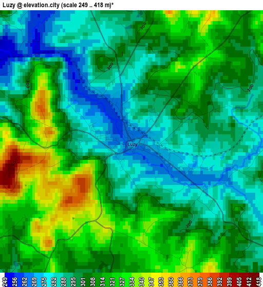
Below is the Elevation map of Luzy, which displays elevation range with different colors. Scale of the first map is from 249 to 418 m (817 to 1371 ft) with average elevation of 303.8 meters (=997 ft) [note 1]
These maps also provides idea of topography and contour of this city, they are displayed at different zoom levels. More info about maps, scale and edge coordinates you can find below images.
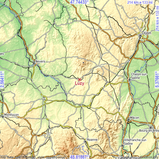
| \ | Map #1 | Topo.Map |
| Scale [m] | 249..418 m | × |
| Scale [ft] | 817..1371 ft | × |
| Average | 303.8 m = 997 ft | × |
| Width | 6.69 km = 4.2 mi | 214.1 km = 133 mi |
| Height | 6.69 km = 4.2 mi | 214.1 km = 133 mi |
| ↑Max Latitude | 46.82019° | 47.74433° |
| Latitude at center | 46.79011° | 46.79011° |
| ↓Min Latitude | 46.760013° | 45.81867° |
| ← Min Longitude | 3.926415° | 2.56411° |
| Longitude center | 3.97036° | 3.97036° |
| →Max Longitude | 4.014305° | 5.37661° |
Nearby cities:
Cities around Luzy sort by population:
• Autun elevation 320 m
30.7 km,  54°
54°
• Gueugnon 243 m
21.9 km,  161°
161°
• Bourbon-Lancy 254 m
24.2 km,  219°
219°
• Sanvignes-les-Mines 336 m
28.2 km,  119°
119°
• Cercy-la-Tour 200 m
25.9 km,  287°
287°
• Étang-sur-Arroux 273 m
18.7 km,  63°
63°
• Perrecy-les-Forges 286 m
26.9 km,  136°
136°
• Toulon-sur-Arroux 264 m
16.7 km,  129°
129°
• Moulins-Engilbert 230 m
25.1 km,  331°
331°
• Génelard 272 m
30.8 km, 138°
• Marmagne 317 m
30 km,  80°
80°
• Saint-Berain-sous-Sanvignes 322 m
26.3 km,  110°
110°
Multilingual:
 En español:
Luzy elevación 266 m.
 En France:
Luzy élévation 266 m.


Sources and notes:
- [note 1] Map square and city borders are not equal. Map elevation data is calculated only from area inside that square.
- [src 1] Elevation data from geonames database provided with same terms of usage.
- [src 2] The elevation map of Luzy is generated using elevation data from NASA's 3 arcsec (90m) resolution SRTM data.
- [src 3] Base (background) map © OpenStreetMap contributors tiles are generated by Geofabrik and OpenTopoMap.
Copyright & License:
This Luzy Elevation Map is licensed under CC BY-SA. You may reuse any part from this page, if you give a proper credit by linking to this URL:
 More info on terms of use page.