Maîche elevation
Maîche (Bourgogne-Franche-Comté, Doubs), France elevation is 783 meters and Maîche elevation in feet is 2569 ft above sea level [src 1]. Maîche is a populated place (feature code) with elevation that is 609 meters (1998 ft) bigger than average city elevation in France.
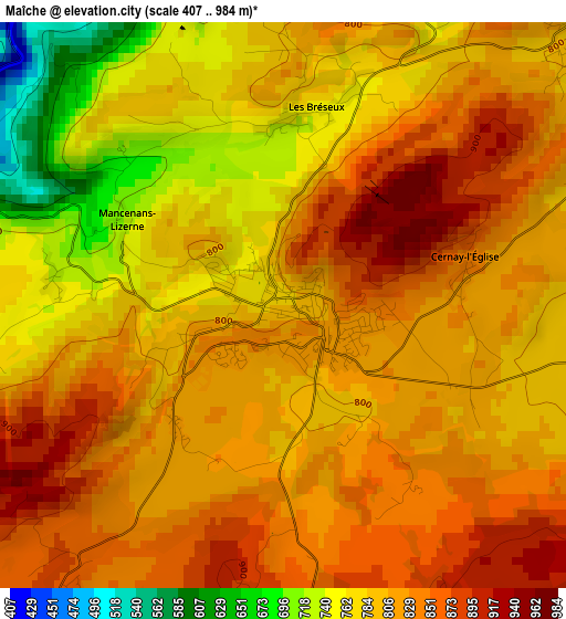
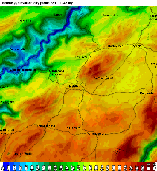
Below is the Elevation map of Maîche, which displays elevation range with different colors. Scale of the first map is from 407 to 984 m (1335 to 3228 ft) with average elevation of 808.1 meters (=2651 ft) [note 1]
These maps also provides idea of topography and contour of this city, they are displayed at different zoom levels. More info about maps, scale and edge coordinates you can find below images.
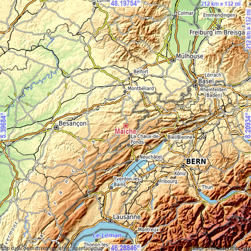
| \ | Map #1 | Map #2 | Topo.Map |
| Scale [m] | 407..984 m | 381..1043 m | × |
| Scale [ft] | 1335..3228 ft | 1250..3422 ft | × |
| Average | 808.1 m = 2651 ft | 776.7 m = 2548 ft | × |
| Width | 6.63 km = 4.1 mi | 13.27 km = 8.2 mi | 212.3 km = 131.9 mi |
| Height | 6.63 km = 4.1 mi | 13.27 km = 8.2 mi | 212.3 km = 131.9 mi |
| ↑Max Latitude | 47.281421° | 47.311225° | 48.19754° |
| Latitude at center | 47.2516° | 47.2516° | 47.2516° |
| ↓Min Latitude | 47.221762° | 47.191908° | 46.28846° |
| ← Min Longitude | 6.759145° | 6.715199° | 5.39684° |
| Longitude center | 6.80309° | 6.80309° | 6.80309° |
| →Max Longitude | 6.847035° | 6.890981° | 8.20934° |
Nearby cities:
Cities around Maîche sort by population:
• Mandeure elevation 330 m
22 km,  0°
0°
• Pont-de-Roide 359 m
15.3 km,  350°
350°
• Villers-le-Lac 835 m
23.3 km,  206°
206°
• Hérimoncourt 360 m
22.1 km,  15°
15°
• Charquemont 870 m
4.3 km,  163°
163°
• Mathay 339 m
20.9 km,  356°
356°
• Le Russey 882 m
11.6 km, 208°
• Damprichard 820 m
6 km,  98°
98°
• Pierrefontaine-les-Varans 692 m
20.2 km,  258°
258°
• Blamont 564 m
15.2 km,  12°
12°
• Saint-Hippolyte 377 m
7.5 km, 7°
• Sancey-le-Grand 503 m
17.3 km,  286°
286°
Multilingual:
 En español:
Maîche elevación 783 m.
 En France:
Maîche élévation 783 m.


Sources and notes:
- [note 1] Map square and city borders are not equal. Map elevation data is calculated only from area inside that square.
- [src 1] Elevation data from geonames database provided with same terms of usage.
- [src 2] The elevation map of Maîche is generated using elevation data from NASA's 3 arcsec (90m) resolution SRTM data.
- [src 3] Base (background) map © OpenStreetMap contributors tiles are generated by Geofabrik and OpenTopoMap.
Copyright & License:
This Maîche Elevation Map is licensed under CC BY-SA. You may reuse any part from this page, if you give a proper credit by linking to this URL:
 More info on terms of use page.