Mane elevation
Mane (Provence-Alpes-Côte d'Azur, Alpes-de-Haute-Provence), France elevation is 454 meters and Mane elevation in feet is 1490 ft above sea level [src 1]. Mane is a populated place (feature code) with elevation that is 280 meters (919 ft) bigger than average city elevation in France.
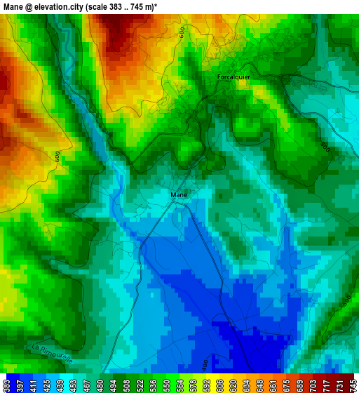
Below is the Elevation map of Mane, which displays elevation range with different colors. Scale of the first map is from 383 to 745 m (1257 to 2444 ft) with average elevation of 504.4 meters (=1655 ft) [note 1]
These maps also provides idea of topography and contour of this city, they are displayed at different zoom levels. More info about maps, scale and edge coordinates you can find below images.
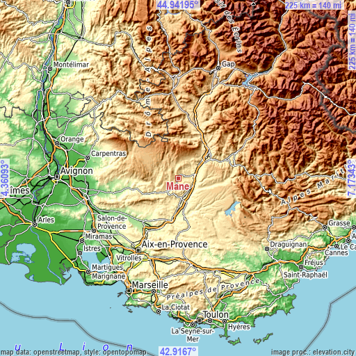
| \ | Map #1 | Topo.Map |
| Scale [m] | 383..745 m | × |
| Scale [ft] | 1257..2444 ft | × |
| Average | 504.4 m = 1655 ft | × |
| Width | 7.04 km = 4.4 mi | 225.2 km = 139.9 mi |
| Height | 7.04 km = 4.4 mi | 225.2 km = 139.9 mi |
| ↑Max Latitude | 43.969586° | 44.94195° |
| Latitude at center | 43.93795° | 43.93795° |
| ↓Min Latitude | 43.906297° | 42.9167° |
| ← Min Longitude | 5.723235° | 4.36093° |
| Longitude center | 5.76718° | 5.76718° |
| →Max Longitude | 5.811125° | 7.17343° |
Nearby cities:
Cities around Mane sort by population:
• Manosque elevation 364 m
12.2 km,  172°
172°
• Forcalquier 530 m
2.6 km,  22°
22°
• Oraison 437 m
12.3 km,  100°
100°
• Pierrevert 394 m
14.1 km,  185°
185°
• Sainte-Tulle 304 m
16.9 km,  180°
180°
• Villeneuve 434 m
9.1 km,  122°
122°
• Les Mées 544 m
19.6 km,  58°
58°
• Volx 349 m
8.9 km,  138°
138°
• Peyruis 390 m
17.1 km,  53°
53°
• Reillanne 560 m
10.9 km,  232°
232°
• Céreste 397 m
17.1 km,  237°
237°
• Saint-Michel-l’Observatoire 561 m
5.2 km, 232°
Multilingual:
 En español:
Mane elevación 454 m.
 En France:
Mane élévation 454 m.


Sources and notes:
- [note 1] Map square and city borders are not equal. Map elevation data is calculated only from area inside that square.
- [src 1] Elevation data from geonames database provided with same terms of usage.
- [src 2] The elevation map of Mane is generated using elevation data from NASA's 3 arcsec (90m) resolution SRTM data.
- [src 3] Base (background) map © OpenStreetMap contributors tiles are generated by Geofabrik and OpenTopoMap.
Copyright & License:
This Mane Elevation Map is licensed under CC BY-SA. You may reuse any part from this page, if you give a proper credit by linking to this URL:
 More info on terms of use page.