Manzat elevation
Manzat (Auvergne-Rhône-Alpes, Département du Puy-de-Dôme), France elevation is 632 meters and Manzat elevation in feet is 2073 ft above sea level [src 1]. Manzat is a populated place (feature code) with elevation that is 458 meters (1503 ft) bigger than average city elevation in France.
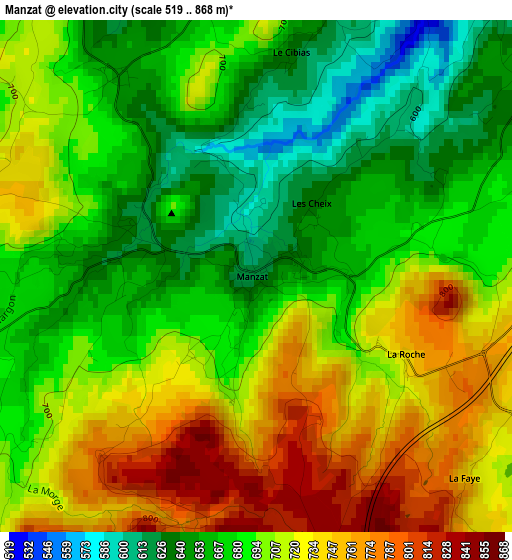
Below is the Elevation map of Manzat, which displays elevation range with different colors. Scale of the first map is from 519 to 868 m (1703 to 2848 ft) with average elevation of 696.5 meters (=2285 ft) [note 1]
These maps also provides idea of topography and contour of this city, they are displayed at different zoom levels. More info about maps, scale and edge coordinates you can find below images.
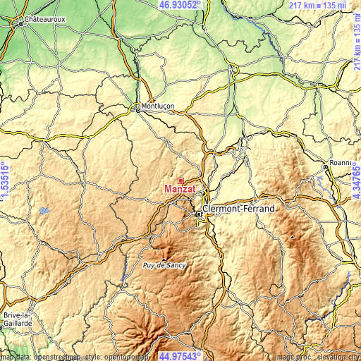
| \ | Map #1 | Topo.Map |
| Scale [m] | 519..868 m | × |
| Scale [ft] | 1703..2848 ft | × |
| Average | 696.5 m = 2285 ft | × |
| Width | 6.79 km = 4.2 mi | 217.4 km = 135.1 mi |
| Height | 6.79 km = 4.2 mi | 217.4 km = 135.1 mi |
| ↑Max Latitude | 45.99214° | 46.93052° |
| Latitude at center | 45.9616° | 45.9616° |
| ↓Min Latitude | 45.931043° | 44.97543° |
| ← Min Longitude | 2.897455° | 1.53515° |
| Longitude center | 2.9414° | 2.9414° |
| →Max Longitude | 2.985345° | 4.34765° |
Nearby cities:
Cities around Manzat sort by population:
• Châtel-Guyon elevation 421 m
10.4 km,  114°
114°
• Volvic 502 m
12.5 km,  143°
143°
• Mozac 349 m
14.1 km,  122°
122°
• Saint-Georges-de-Mons 732 m
8.3 km,  252°
252°
• Combronde 400 m
11.5 km,  79°
79°
• Les Ancizes 695 m
10.7 km, 247°
• Saint-Bonnet-près-Riom 368 m
13.7 km,  104°
104°
• Saint-Gervais-d’Auvergne 720 m
12.1 km,  308°
308°
• Saint-Ours 812 m
13 km,  197°
197°
• Enval 445 m
10.9 km,  129°
129°
• Charbonnières-les-Varennes 719 m
7.5 km, 142°
• Chapdes-Beaufort 789 m
9.7 km,  218°
218°
Multilingual:
 En español:
Manzat elevación 632 m.
 En France:
Manzat élévation 632 m.


Sources and notes:
- [note 1] Map square and city borders are not equal. Map elevation data is calculated only from area inside that square.
- [src 1] Elevation data from geonames database provided with same terms of usage.
- [src 2] The elevation map of Manzat is generated using elevation data from NASA's 3 arcsec (90m) resolution SRTM data.
- [src 3] Base (background) map © OpenStreetMap contributors tiles are generated by Geofabrik and OpenTopoMap.
Copyright & License:
This Manzat Elevation Map is licensed under CC BY-SA. You may reuse any part from this page, if you give a proper credit by linking to this URL:
 More info on terms of use page.