Marignier elevation
Marignier (Auvergne-Rhône-Alpes, Haute-Savoie), France elevation is 473 meters and Marignier elevation in feet is 1552 ft above sea level [src 1]. Marignier is a populated place (feature code) with elevation that is 299 meters (981 ft) bigger than average city elevation in France.
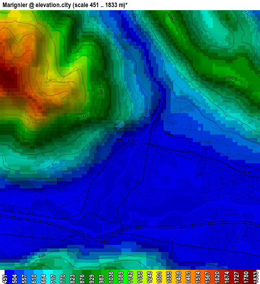
Below is the Elevation map of Marignier, which displays elevation range with different colors. Scale of the first map is from 451 to 1833 m (1480 to 6014 ft) with average elevation of 713.2 meters (=2340 ft) [note 1]
These maps also provides idea of topography and contour of this city, they are displayed at different zoom levels. More info about maps, scale and edge coordinates you can find below images.
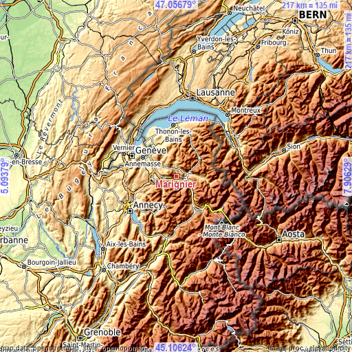
| \ | Map #1 | Map #2 | Topo.Map |
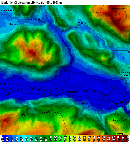
| Scale [m] | 451..1833 m | 445..1953 m | × |
| Scale [ft] | 1480..6014 ft | 1460..6407 ft | × |
| Average | 713.2 m = 2340 ft | 868.3 m = 2849 ft | × |
| Width | 6.78 km = 4.2 mi | 13.56 km = 8.4 mi | 216.9 km = 134.8 mi |
| Height | 6.78 km = 4.2 mi | 13.56 km = 8.4 mi | 216.9 km = 134.8 mi |
| ↑Max Latitude | 46.120609° | 46.151061° | 47.05679° |
| Latitude at center | 46.09014° | 46.09014° | 46.09014° |
| ↓Min Latitude | 46.059654° | 46.029152° | 45.10624° |
| ← Min Longitude | 6.456095° | 6.412149° | 5.09379° |
| Longitude center | 6.50004° | 6.50004° | 6.50004° |
| →Max Longitude | 6.543985° | 6.587931° | 7.90629° |
Nearby cities:
Cities around Marignier sort by population:
• Cluses elevation 484 m
6.5 km,  117°
117°
• Bonneville 450 m
7.2 km,  261°
261°
• Scionzier 480 m
5.3 km,  129°
129°
• Thyez 477 m
3 km,  106°
106°
• Marnaz 484 m
3.6 km,  145°
145°
• Saint-Jeoire 570 m
6 km,  330°
330°
• Ayse 491 m
4.3 km, 256°
• Mieussy 637 m
5.2 km,  21°
21°
• Mont-Saxonnex 954 m
4.8 km,  204°
204°
• La Tour 790 m
7.1 km,  311°
311°
• Châtillon-sur-Cluses 771 m
6.2 km,  92°
92°
• Vougy 458 m
3.3 km,  221°
221°
Multilingual:
 En español:
Marignier elevación 473 m.
 En France:
Marignier élévation 473 m.
 Auf Deutsch:
Marignier höhe über dem Meeresspiegel ist 473 m.

Sources and notes:
- [note 1] Map square and city borders are not equal. Map elevation data is calculated only from area inside that square.
- [src 1] Elevation data from geonames database provided with same terms of usage.
- [src 2] The elevation map of Marignier is generated using elevation data from NASA's 3 arcsec (90m) resolution SRTM data.
- [src 3] Base (background) map © OpenStreetMap contributors tiles are generated by Geofabrik and OpenTopoMap.
Copyright & License:
This Marignier Elevation Map is licensed under CC BY-SA. You may reuse any part from this page, if you give a proper credit by linking to this URL:
 More info on terms of use page.