Marlhes elevation
Marlhes (Auvergne-Rhône-Alpes, Département de la Loire), France elevation is 969 meters and Marlhes elevation in feet is 3179 ft above sea level [src 1]. Marlhes is a populated place (feature code) with elevation that is 795 meters (2608 ft) bigger than average city elevation in France.
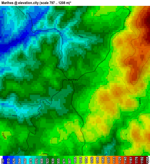
Below is the Elevation map of Marlhes, which displays elevation range with different colors. Scale of the first map is from 797 to 1208 m (2615 to 3963 ft) with average elevation of 963.7 meters (=3162 ft) [note 1]
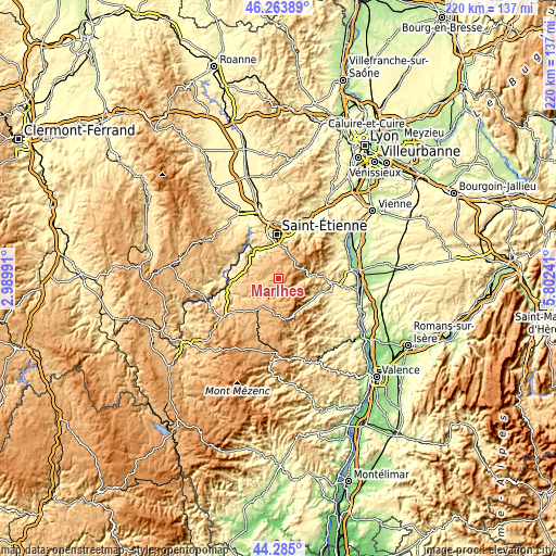
These maps also provides idea of topography and contour of this city, they are displayed at different zoom levels. More info about maps, scale and edge coordinates you can find below images.
| \ | Map #1 | Topo.Map |
| Scale [m] | 797..1208 m | × |
| Scale [ft] | 2615..3963 ft | × |
| Average | 963.7 m = 3162 ft | × |
| Width | 6.88 km = 4.3 mi | 220 km = 136.7 mi |
| Height | 6.88 km = 4.3 mi | 220 km = 136.7 mi |
| ↑Max Latitude | 45.313982° | 46.26389° |
| Latitude at center | 45.28307° | 45.28307° |
| ↓Min Latitude | 45.252141° | 44.285° |
| ← Min Longitude | 4.352215° | 2.98991° |
| Longitude center | 4.39616° | 4.39616° |
| →Max Longitude | 4.440105° | 5.80241° |
Nearby cities:
Cities around Marlhes sort by population:
• Le Chambon-Feugerolles elevation 587 m
13.4 km,  334°
334°
• Saint-Just-Malmont 839 m
9 km,  313°
313°
• Saint-Didier-en-Velay 834 m
9.7 km,  282°
282°
• Dunières 798 m
8.5 km,  208°
208°
• Saint-Genest-Malifaux 947 m
6.6 km,  13°
13°
• Saint-Pal-de-Mons 826 m
10.4 km,  246°
246°
• Pont-Salomon 743 m
13.1 km,  297°
297°
• Jonzieux 849 m
4.3 km,  321°
321°
• Riotord 943 m
5.7 km,  175°
175°
• Saint-Sauveur-en-Rue 753 m
7.9 km,  100°
100°
• La Séauve-sur-Semène 748 m
11.5 km, 276°
• Montfaucon-en-Velay 919 m
12.6 km, 210°
Multilingual:
 En español:
Marlhes elevación 969 m.
 En France:
Marlhes élévation 969 m.


Sources and notes:
- [note 1] Map square and city borders are not equal. Map elevation data is calculated only from area inside that square.
- [src 1] Elevation data from geonames database provided with same terms of usage.
- [src 2] The elevation map of Marlhes is generated using elevation data from NASA's 3 arcsec (90m) resolution SRTM data.
- [src 3] Base (background) map © OpenStreetMap contributors tiles are generated by Geofabrik and OpenTopoMap.
Copyright & License:
This Marlhes Elevation Map is licensed under CC BY-SA. You may reuse any part from this page, if you give a proper credit by linking to this URL:
 More info on terms of use page.