Montfaucon-en-Velay elevation
Montfaucon-en-Velay (Auvergne-Rhône-Alpes, Haute-Loire), France elevation is 919 meters and Montfaucon-en-Velay elevation in feet is 3015 ft above sea level [src 1]. Montfaucon-en-Velay is a populated place (feature code) with elevation that is 745 meters (2444 ft) bigger than average city elevation in France.
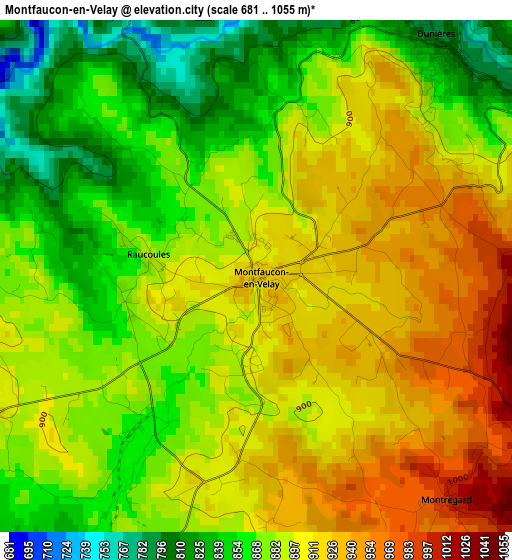
Below is the Elevation map of Montfaucon-en-Velay, which displays elevation range with different colors. Scale of the first map is from 681 to 1055 m (2234 to 3461 ft) with average elevation of 890.5 meters (=2922 ft) [note 1]
These maps also provides idea of topography and contour of this city, they are displayed at different zoom levels. More info about maps, scale and edge coordinates you can find below images.
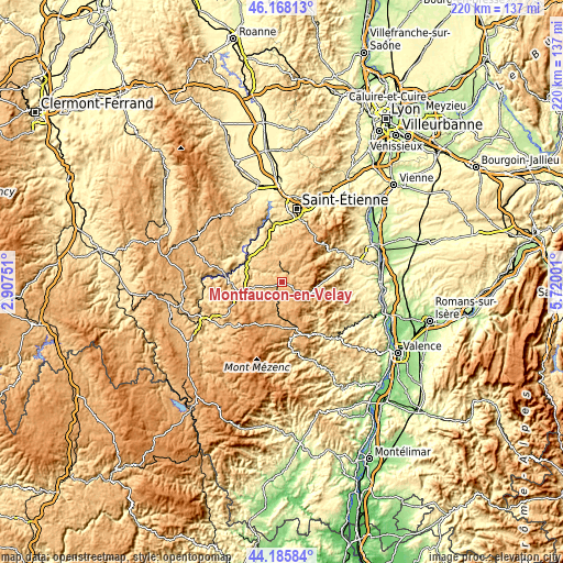
| \ | Map #1 | Topo.Map |
| Scale [m] | 681..1055 m | × |
| Scale [ft] | 2234..3461 ft | × |
| Average | 890.5 m = 2922 ft | × |
| Width | 6.89 km = 4.3 mi | 220.4 km = 136.9 mi |
| Height | 6.89 km = 4.3 mi | 220.4 km = 136.9 mi |
| ↑Max Latitude | 45.216575° | 46.16813° |
| Latitude at center | 45.18561° | 45.18561° |
| ↓Min Latitude | 45.154628° | 44.18584° |
| ← Min Longitude | 4.269815° | 2.90751° |
| Longitude center | 4.31376° | 4.31376° |
| →Max Longitude | 4.357705° | 5.72001° |
Nearby cities:
Cities around Montfaucon-en-Velay sort by population:
• Sainte-Sigolène elevation 818 m
9 km,  315°
315°
• Saint-Didier-en-Velay 834 m
13.4 km,  346°
346°
• Tence 858 m
8.1 km,  192°
192°
• Dunières 798 m
4.1 km,  36°
36°
• Le Chambon-sur-Lignon 961 m
13.9 km,  183°
183°
• Saint-Maurice-de-Lignon 762 m
14.4 km,  287°
287°
• Saint-Pal-de-Mons 826 m
7.4 km,  335°
335°
• Marlhes 969 m
12.6 km,  30°
30°
• Lapte 865 m
7.6 km,  270°
270°
• Jonzieux 849 m
14.7 km,  14°
14°
• Riotord 943 m
8.6 km,  53°
53°
• La Séauve-sur-Semène 748 m
13.2 km, 337°
Multilingual:
 En español:
Montfaucon-en-Velay elevación 919 m.
 En France:
Montfaucon-en-Velay élévation 919 m.
 Auf Deutsch:
Montfaucon-en-Velay höhe über dem Meeresspiegel ist 919 m.
 На русском:
Montfaucon-en-Velay высота над уровнем моря 919 м
Sources and notes:
- [note 1] Map square and city borders are not equal. Map elevation data is calculated only from area inside that square.
- [src 1] Elevation data from geonames database provided with same terms of usage.
- [src 2] The elevation map of Montfaucon-en-Velay is generated using elevation data from NASA's 3 arcsec (90m) resolution SRTM data.
- [src 3] Base (background) map © OpenStreetMap contributors tiles are generated by Geofabrik and OpenTopoMap.
Copyright & License:
This Montfaucon-en-Velay Elevation Map is licensed under CC BY-SA. You may reuse any part from this page, if you give a proper credit by linking to this URL:
 More info on terms of use page.