Mauron elevation
Mauron (Brittany, Morbihan), France elevation is 81 meters and Mauron elevation in feet is 266 ft above sea level [src 1]. Mauron is a populated place (feature code) with elevation that is 93 meters (305 ft) smaller than average city elevation in France.
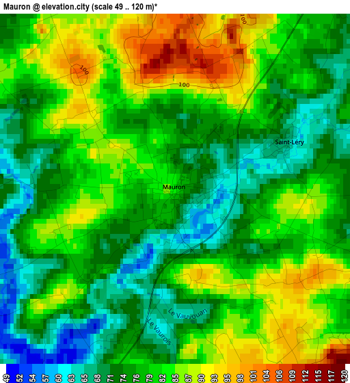
Below is the Elevation map of Mauron, which displays elevation range with different colors. Scale of the first map is from 49 to 120 m (161 to 394 ft) with average elevation of 79 meters (=259 ft) [note 1]
These maps also provides idea of topography and contour of this city, they are displayed at different zoom levels. More info about maps, scale and edge coordinates you can find below images.
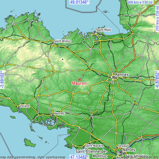
| \ | Map #1 | Topo.Map |
| Scale [m] | 49..120 m | × |
| Scale [ft] | 161..394 ft | × |
| Average | 79 m = 259 ft | × |
| Width | 6.53 km = 4.1 mi | 208.9 km = 129.8 mi |
| Height | 6.53 km = 4.1 mi | 208.9 km = 129.8 mi |
| ↑Max Latitude | 48.11192° | 49.01346° |
| Latitude at center | 48.08257° | 48.08257° |
| ↓Min Latitude | 48.053204° | 47.13452° |
| ← Min Longitude | -2.328715° | -3.69102° |
| Longitude center | -2.28477° | -2.28477° |
| →Max Longitude | -2.240825° | -0.87852° |
Nearby cities:
Cities around Mauron sort by population:
• Saint-Méen-le-Grand elevation 107 m
13.7 km,  29°
29°
• Plélan-le-Grand 137 m
16.5 km,  123°
123°
• Merdrignac 149 m
15.7 km,  321°
321°
• Taupont 80 m
17.9 km,  220°
220°
• Ménéac 170 m
14.6 km,  295°
295°
• Campénéac 79 m
13.9 km,  182°
182°
• Loyat 62 m
12.7 km, 215°
• Paimpont 158 m
11.1 km,  130°
130°
• Gaël 83 m
7.2 km,  39°
39°
• Guilliers 89 m
10 km,  243°
243°
• Augan 85 m
18.1 km, 178°
• Beignon 122 m
15 km,  145°
145°
Multilingual:
 En español:
Mauron elevación 81 m.
 En France:
Mauron élévation 81 m.


Sources and notes:
- [note 1] Map square and city borders are not equal. Map elevation data is calculated only from area inside that square.
- [src 1] Elevation data from geonames database provided with same terms of usage.
- [src 2] The elevation map of Mauron is generated using elevation data from NASA's 3 arcsec (90m) resolution SRTM data.
- [src 3] Base (background) map © OpenStreetMap contributors tiles are generated by Geofabrik and OpenTopoMap.
Copyright & License:
This Mauron Elevation Map is licensed under CC BY-SA. You may reuse any part from this page, if you give a proper credit by linking to this URL:
 More info on terms of use page.