Merdrignac elevation
Merdrignac (Brittany, Département des Côtes-d’Armor), France elevation is 149 meters and Merdrignac elevation in feet is 489 ft above sea level [src 1]. Merdrignac is a populated place (feature code) with elevation that is 25 meters (82 ft) smaller than average city elevation in France.
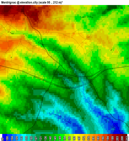
Below is the Elevation map of Merdrignac, which displays elevation range with different colors. Scale of the first map is from 95 to 212 m (312 to 696 ft) with average elevation of 148.2 meters (=486 ft) [note 1]
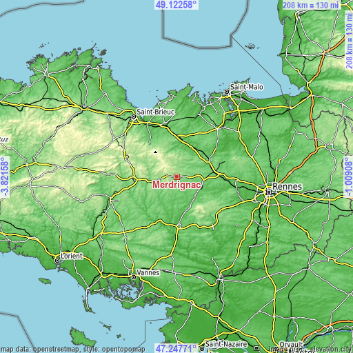
These maps also provides idea of topography and contour of this city, they are displayed at different zoom levels. More info about maps, scale and edge coordinates you can find below images.
| \ | Map #1 | Topo.Map |
| Scale [m] | 95..212 m | × |
| Scale [ft] | 312..696 ft | × |
| Average | 148.2 m = 486 ft | × |
| Width | 6.51 km = 4 mi | 208.5 km = 129.6 mi |
| Height | 6.51 km = 4 mi | 208.5 km = 129.6 mi |
| ↑Max Latitude | 48.223006° | 49.12258° |
| Latitude at center | 48.19372° | 48.19372° |
| ↓Min Latitude | 48.164417° | 47.24771° |
| ← Min Longitude | -2.459275° | -3.82158° |
| Longitude center | -2.41533° | -2.41533° |
| →Max Longitude | -2.371385° | -1.00908° |
Nearby cities:
Cities around Merdrignac sort by population:
• Saint-Méen-le-Grand elevation 107 m
16.3 km,  91°
91°
• Mauron 81 m
15.7 km,  141°
141°
• Plémet 147 m
13.3 km,  261°
261°
• Broons 95 m
18 km,  39°
39°
• Plénée-Jugon 69 m
19 km,  3°
3°
• Ménéac 170 m
6.9 km,  209°
209°
• Plessala 198 m
17.7 km,  301°
301°
• Gaël 83 m
15.8 km,  115°
115°
• Guilliers 89 m
16.8 km,  177°
177°
• Plumieux 131 m
16.1 km,  231°
231°
• Sévignac 69 m
16.5 km,  20°
20°
• Plumaugat 114 m
14.8 km,  62°
62°
Multilingual:
 En español:
Merdrignac elevación 149 m.
 En France:
Merdrignac élévation 149 m.
 Auf Deutsch:
Merdrignac höhe über dem Meeresspiegel ist 149 m.

Sources and notes:
- [note 1] Map square and city borders are not equal. Map elevation data is calculated only from area inside that square.
- [src 1] Elevation data from geonames database provided with same terms of usage.
- [src 2] The elevation map of Merdrignac is generated using elevation data from NASA's 3 arcsec (90m) resolution SRTM data.
- [src 3] Base (background) map © OpenStreetMap contributors tiles are generated by Geofabrik and OpenTopoMap.
Copyright & License:
This Merdrignac Elevation Map is licensed under CC BY-SA. You may reuse any part from this page, if you give a proper credit by linking to this URL:
 More info on terms of use page.