Mazamet elevation
Mazamet (Occitanie, Tarn), France elevation is 259 meters and Mazamet elevation in feet is 850 ft above sea level [src 1]. Mazamet is a populated place (feature code) with elevation that is 85 meters (279 ft) bigger than average city elevation in France.
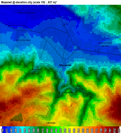
Below is the Elevation map of Mazamet, which displays elevation range with different colors. Scale of the first map is from 192 to 837 m (630 to 2746 ft) with average elevation of 408.5 meters (=1340 ft) [note 1]
These maps also provides idea of topography and contour of this city, they are displayed at different zoom levels. More info about maps, scale and edge coordinates you can find below images.
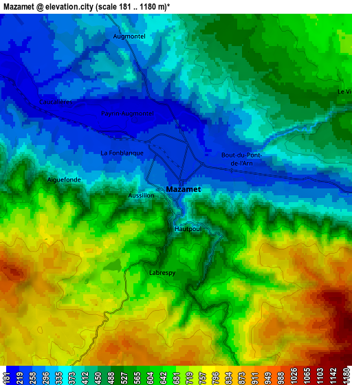
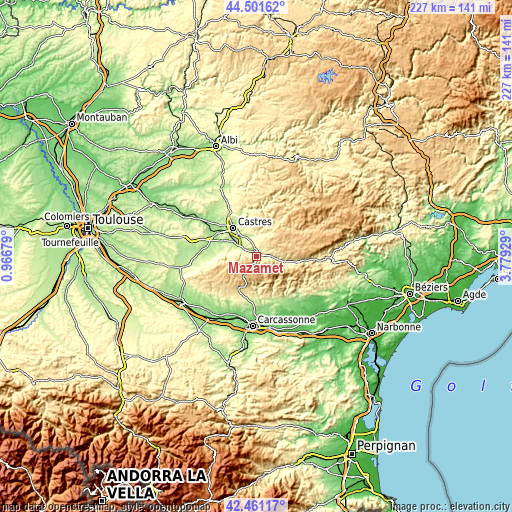
| \ | Map #1 | Map #2 | Topo.Map |
| Scale [m] | 192..837 m | 181..1180 m | × |
| Scale [ft] | 630..2746 ft | 594..3871 ft | × |
| Average | 408.5 m = 1340 ft | 534.7 m = 1754 ft | × |
| Width | 7.09 km = 4.4 mi | 14.18 km = 8.8 mi | 226.9 km = 141 mi |
| Height | 7.09 km = 4.4 mi | 14.18 km = 8.8 mi | 226.9 km = 141 mi |
| ↑Max Latitude | 43.521884° | 43.55374° | 44.50162° |
| Latitude at center | 43.49001° | 43.49001° | 43.49001° |
| ↓Min Latitude | 43.45812° | 43.426212° | 42.46117° |
| ← Min Longitude | 2.329095° | 2.285149° | 0.96679° |
| Longitude center | 2.37304° | 2.37304° | 2.37304° |
| →Max Longitude | 2.416985° | 2.460931° | 3.77929° |
Nearby cities:
Cities around Mazamet sort by population:
• Castres elevation 178 m
16.8 km,  320°
320°
• Aussillon 239 m
1.5 km,  343°
343°
• Labruguière 191 m
10.3 km,  301°
301°
• Pont-de-Larn 246 m
3.2 km,  60°
60°
• Aiguefonde 345 m
4.6 km,  275°
275°
• Payrin-Augmontel 340 m
6.2 km,  345°
345°
• Burlats 198 m
16.8 km, 344°
• Saint-Amans-Soult 288 m
9.6 km,  98°
98°
• Lagarrigue 208 m
12.4 km, 321°
• Bout-du-Pont-de-Larn 248 m
3.6 km,  76°
76°
• Saint-Amans-Valtoret 288 m
9.6 km, 96°
• Cuxac-Cabardès 519 m
15.1 km,  208°
208°
Multilingual:
 En español:
Mazamet elevación 259 m.
 En France:
Mazamet élévation 259 m.


Sources and notes:
- [note 1] Map square and city borders are not equal. Map elevation data is calculated only from area inside that square.
- [src 1] Elevation data from geonames database provided with same terms of usage.
- [src 2] The elevation map of Mazamet is generated using elevation data from NASA's 3 arcsec (90m) resolution SRTM data.
- [src 3] Base (background) map © OpenStreetMap contributors tiles are generated by Geofabrik and OpenTopoMap.
Copyright & License:
This Mazamet Elevation Map is licensed under CC BY-SA. You may reuse any part from this page, if you give a proper credit by linking to this URL:
 More info on terms of use page.