Melle elevation
Melle (Nouvelle-Aquitaine, Département des Deux-Sèvres), France elevation is 134 meters and Melle elevation in feet is 440 ft above sea level [src 1]. Melle is a populated place (feature code) with elevation that is 40 meters (131 ft) smaller than average city elevation in France.
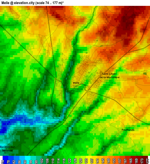
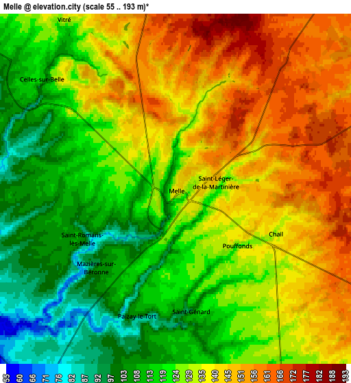
Below is the Elevation map of Melle, which displays elevation range with different colors. Scale of the first map is from 74 to 177 m (243 to 581 ft) with average elevation of 129.6 meters (=425 ft) [note 1]
These maps also provides idea of topography and contour of this city, they are displayed at different zoom levels. More info about maps, scale and edge coordinates you can find below images.
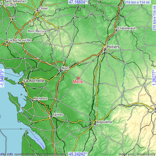
| \ | Map #1 | Map #2 | Topo.Map |
| Scale [m] | 74..177 m | 55..193 m | × |
| Scale [ft] | 243..581 ft | 180..633 ft | × |
| Average | 129.6 m = 425 ft | 130 m = 427 ft | × |
| Width | 6.76 km = 4.2 mi | 13.52 km = 8.4 mi | 216.4 km = 134.5 mi |
| Height | 6.76 km = 4.2 mi | 13.52 km = 8.4 mi | 216.3 km = 134.4 mi |
| ↑Max Latitude | 46.254345° | 46.284723° | 47.18824° |
| Latitude at center | 46.22395° | 46.22395° | 46.22395° |
| ↓Min Latitude | 46.193538° | 46.16311° | 45.24242° |
| ← Min Longitude | -0.187425° | -0.231371° | -1.54973° |
| Longitude center | -0.14348° | -0.14348° | -0.14348° |
| →Max Longitude | -0.099535° | -0.055589° | 1.26277° |
Nearby cities:
Cities around Melle sort by population:
• La Crèche elevation 43 m
19.9 km,  322°
322°
• Celles-sur-Belle 120 m
6.7 km,  308°
308°
• Vouillé 53 m
20 km,  300°
300°
• Chef-Boutonne 95 m
14 km,  156°
156°
• Lezay 131 m
11.3 km,  66°
66°
• La Mothe-Saint-Héray 113 m
15.4 km,  8°
8°
• Prahecq 42 m
16 km,  284°
284°
• Mougon 86 m
13.6 km, 305°
• Pamproux 98 m
20.4 km,  19°
19°
• Brioux-sur-Boutonne 63 m
11 km,  213°
213°
• Fors 51 m
20.5 km,  273°
273°
• Thorigné 109 m
11.2 km, 312°
Multilingual:
 En español:
Melle elevación 134 m.
 En France:
Melle élévation 134 m.


Sources and notes:
- [note 1] Map square and city borders are not equal. Map elevation data is calculated only from area inside that square.
- [src 1] Elevation data from geonames database provided with same terms of usage.
- [src 2] The elevation map of Melle is generated using elevation data from NASA's 3 arcsec (90m) resolution SRTM data.
- [src 3] Base (background) map © OpenStreetMap contributors tiles are generated by Geofabrik and OpenTopoMap.
Copyright & License:
This Melle Elevation Map is licensed under CC BY-SA. You may reuse any part from this page, if you give a proper credit by linking to this URL:
 More info on terms of use page.