Moissy-Cramayel elevation
Moissy-Cramayel (Île-de-France, Seine-et-Marne), France elevation is 91 meters and Moissy-Cramayel elevation in feet is 299 ft above sea level [src 1]. Moissy-Cramayel is a populated place (feature code) with elevation that is 83 meters (272 ft) smaller than average city elevation in France.
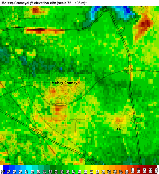
Below is the Elevation map of Moissy-Cramayel, which displays elevation range with different colors. Scale of the first map is from 72 to 105 m (236 to 344 ft) with average elevation of 87.5 meters (=287 ft) [note 1]
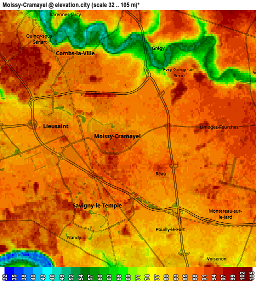
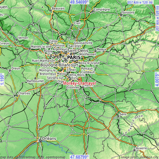
These maps also provides idea of topography and contour of this city, they are displayed at different zoom levels. More info about maps, scale and edge coordinates you can find below images.
| \ | Map #1 | Map #2 | Topo.Map |
| Scale [m] | 72..105 m | 32..105 m | × |
| Scale [ft] | 236..344 ft | 105..344 ft | × |
| Average | 87.5 m = 287 ft | 84 m = 276 ft | × |
| Width | 6.46 km = 4 mi | 12.92 km = 8 mi | 206.7 km = 128.4 mi |
| Height | 6.46 km = 4 mi | 12.92 km = 8 mi | 206.7 km = 128.4 mi |
| ↑Max Latitude | 48.655088° | 48.68411° | 49.54699° |
| Latitude at center | 48.62605° | 48.62605° | 48.62605° |
| ↓Min Latitude | 48.596995° | 48.567923° | 47.68799° |
| ← Min Longitude | 2.557305° | 2.513359° | 1.195° |
| Longitude center | 2.60125° | 2.60125° | 2.60125° |
| →Max Longitude | 2.645195° | 2.689141° | 4.0075° |
Nearby cities:
Cities around Moissy-Cramayel sort by population:
• Savigny-le-Temple elevation 75 m
5.9 km,  193°
193°
• Combs-la-Ville 81 m
4.9 km,  331°
331°
• Brie-Comte-Robert 81 m
7.4 km,  5°
5°
• Vert-Saint-Denis 80 m
6.6 km,  167°
167°
• Quincy-sous-Sénart 85 m
7.2 km,  316°
316°
• Cesson 82 m
7.1 km,  175°
175°
• Lieusaint 88 m
4 km,  283°
283°
• Nandy 82 m
5.6 km,  210°
210°
• Soignolles-en-Brie 65 m
7.8 km,  67°
67°
• Varennes-Jarcy 57 m
6.6 km, 333°
• Tigery 76 m
7.1 km, 284°
• Voisenon 79 m
7.6 km,  142°
142°
Multilingual:
 En español:
Moissy-Cramayel elevación 91 m.
 En France:
Moissy-Cramayel élévation 91 m.
 Auf Deutsch:
Moissy-Cramayel höhe über dem Meeresspiegel ist 91 m.

Sources and notes:
- [note 1] Map square and city borders are not equal. Map elevation data is calculated only from area inside that square.
- [src 1] Elevation data from geonames database provided with same terms of usage.
- [src 2] The elevation map of Moissy-Cramayel is generated using elevation data from NASA's 3 arcsec (90m) resolution SRTM data.
- [src 3] Base (background) map © OpenStreetMap contributors tiles are generated by Geofabrik and OpenTopoMap.
Copyright & License:
This Moissy-Cramayel Elevation Map is licensed under CC BY-SA. You may reuse any part from this page, if you give a proper credit by linking to this URL:
 More info on terms of use page.