Moncontour elevation
Moncontour (Nouvelle-Aquitaine, Vienne), France elevation is 59 meters and Moncontour elevation in feet is 194 ft above sea level [src 1]. Moncontour is a populated place (feature code) with elevation that is 115 meters (377 ft) smaller than average city elevation in France.
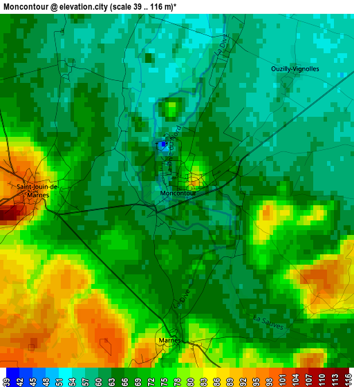
Below is the Elevation map of Moncontour, which displays elevation range with different colors. Scale of the first map is from 39 to 116 m (128 to 381 ft) with average elevation of 68.1 meters (=223 ft) [note 1]
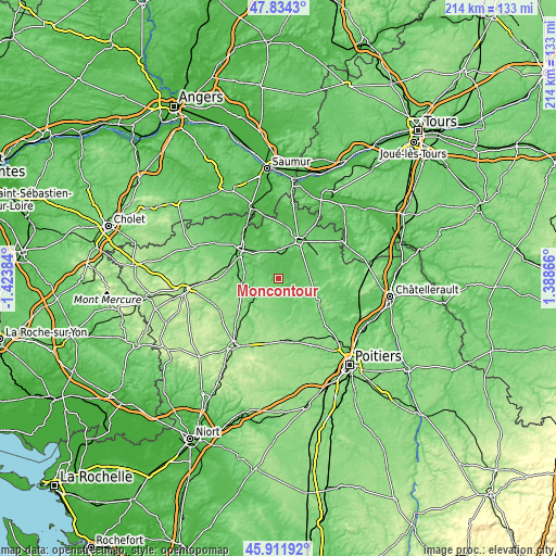
These maps also provides idea of topography and contour of this city, they are displayed at different zoom levels. More info about maps, scale and edge coordinates you can find below images.
| \ | Map #1 | Topo.Map |
| Scale [m] | 39..116 m | × |
| Scale [ft] | 128..381 ft | × |
| Average | 68.1 m = 223 ft | × |
| Width | 6.68 km = 4.2 mi | 213.7 km = 132.8 mi |
| Height | 6.68 km = 4.2 mi | 213.7 km = 132.8 mi |
| ↑Max Latitude | 46.911749° | 47.8343° |
| Latitude at center | 46.88172° | 46.88172° |
| ↓Min Latitude | 46.851675° | 45.91192° |
| ← Min Longitude | -0.061535° | -1.42384° |
| Longitude center | -0.01759° | -0.01759° |
| →Max Longitude | 0.026355° | 1.38866° |
Nearby cities:
Cities around Moncontour sort by population:
• Thouars elevation 94 m
18.5 km,  306°
306°
• Loudun 95 m
16 km,  28°
28°
• Airvault 118 m
11 km,  236°
236°
• Saint-Varent 102 m
16.3 km,  273°
273°
• Mirebeau 150 m
18.6 km,  125°
125°
• Sainte-Radegonde 96 m
21 km,  302°
302°
• Thénezay 137 m
18 km,  182°
182°
• Saint-Jean-de-Sauves 82 m
9.5 km,  118°
118°
• Saint-Jean-de-Thouars 96 m
17.3 km, 301°
• Sainte-Verge 68 m
20.3 km, 313°
• Louzy 54 m
19.3 km,  318°
318°
• Saint-Léger-de-Montbrun 100 m
15.8 km,  326°
326°
Multilingual:
 En español:
Moncontour elevación 59 m.
 En France:
Moncontour élévation 59 m.
 Auf Deutsch:
Moncontour höhe über dem Meeresspiegel ist 59 m.

Sources and notes:
- [note 1] Map square and city borders are not equal. Map elevation data is calculated only from area inside that square.
- [src 1] Elevation data from geonames database provided with same terms of usage.
- [src 2] The elevation map of Moncontour is generated using elevation data from NASA's 3 arcsec (90m) resolution SRTM data.
- [src 3] Base (background) map © OpenStreetMap contributors tiles are generated by Geofabrik and OpenTopoMap.
Copyright & License:
This Moncontour Elevation Map is licensed under CC BY-SA. You may reuse any part from this page, if you give a proper credit by linking to this URL:
 More info on terms of use page.