Montguyon elevation
Montguyon (Nouvelle-Aquitaine, Charente-Maritime), France elevation is 67 meters and Montguyon elevation in feet is 220 ft above sea level [src 1]. Montguyon is a populated place (feature code) with elevation that is 107 meters (351 ft) smaller than average city elevation in France.
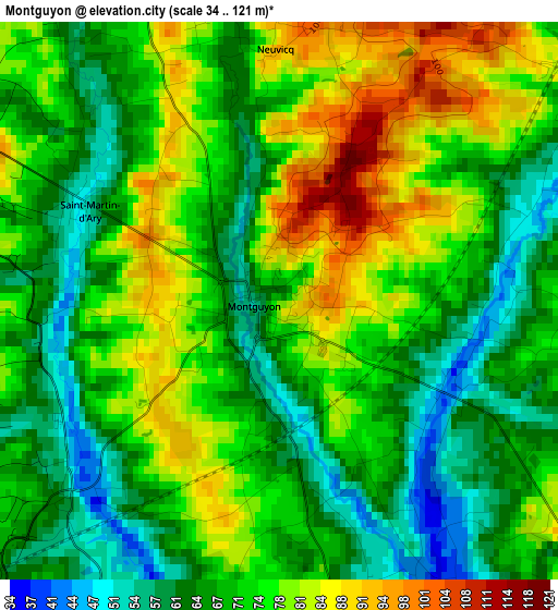
Below is the Elevation map of Montguyon, which displays elevation range with different colors. Scale of the first map is from 34 to 121 m (112 to 397 ft) with average elevation of 71.8 meters (=236 ft) [note 1]
These maps also provides idea of topography and contour of this city, they are displayed at different zoom levels. More info about maps, scale and edge coordinates you can find below images.
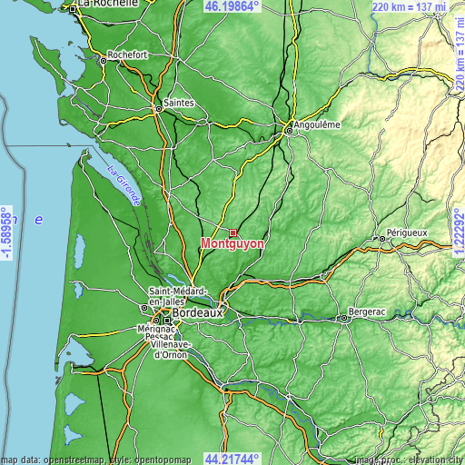
| \ | Map #1 | Topo.Map |
| Scale [m] | 34..121 m | × |
| Scale [ft] | 112..397 ft | × |
| Average | 71.8 m = 236 ft | × |
| Width | 6.88 km = 4.3 mi | 220.3 km = 136.9 mi |
| Height | 6.88 km = 4.3 mi | 220.3 km = 136.9 mi |
| ↑Max Latitude | 45.247618° | 46.19864° |
| Latitude at center | 45.21667° | 45.21667° |
| ↓Min Latitude | 45.185705° | 44.21744° |
| ← Min Longitude | -0.227275° | -1.58958° |
| Longitude center | -0.18333° | -0.18333° |
| →Max Longitude | -0.139385° | 1.22292° |
Nearby cities:
Cities around Montguyon sort by population:
• La Roche-Chalais elevation 63 m
17.3 km,  115°
115°
• Saint-Aigulin 29 m
15.2 km, 115°
• Les Églisottes-et-Chalaures 28 m
17.4 km,  139°
139°
• Chalais 59 m
18.5 km,  70°
70°
• Laruscade 53 m
16.2 km,  226°
226°
• Lagorce 8 m
17.1 km,  166°
166°
• Montlieu-la-Garde 117 m
6.4 km,  305°
305°
• Les Peintures 18 m
17.9 km,  158°
158°
• Chevanceaux 103 m
10.1 km,  337°
337°
• Baignes-Sainte-Radegonde 76 m
18.9 km,  348°
348°
• Cercoux 65 m
9.4 km,  188°
188°
• Clérac 62 m
4.5 km,  215°
215°
Multilingual:
 En español:
Montguyon elevación 67 m.
 En France:
Montguyon élévation 67 m.
 Auf Deutsch:
Montguyon höhe über dem Meeresspiegel ist 67 m.

Sources and notes:
- [note 1] Map square and city borders are not equal. Map elevation data is calculated only from area inside that square.
- [src 1] Elevation data from geonames database provided with same terms of usage.
- [src 2] The elevation map of Montguyon is generated using elevation data from NASA's 3 arcsec (90m) resolution SRTM data.
- [src 3] Base (background) map © OpenStreetMap contributors tiles are generated by Geofabrik and OpenTopoMap.
Copyright & License:
This Montguyon Elevation Map is licensed under CC BY-SA. You may reuse any part from this page, if you give a proper credit by linking to this URL:
 More info on terms of use page.