Noirétable elevation
Noirétable (Auvergne-Rhône-Alpes, Département de la Loire), France elevation is 718 meters and Noirétable elevation in feet is 2356 ft above sea level [src 1]. Noirétable is a populated place (feature code) with elevation that is 544 meters (1785 ft) bigger than average city elevation in France.
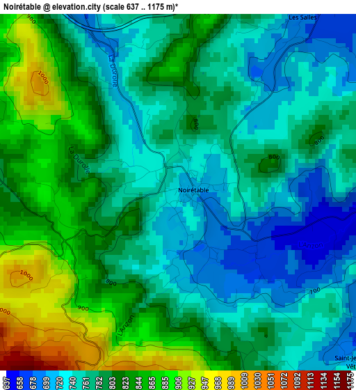
Below is the Elevation map of Noirétable, which displays elevation range with different colors. Scale of the first map is from 637 to 1175 m (2090 to 3855 ft) with average elevation of 789.8 meters (=2591 ft) [note 1]
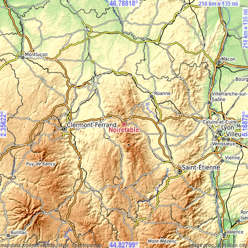
These maps also provides idea of topography and contour of this city, they are displayed at different zoom levels. More info about maps, scale and edge coordinates you can find below images.
| \ | Map #1 | Topo.Map |
| Scale [m] | 637..1175 m | × |
| Scale [ft] | 2090..3855 ft | × |
| Average | 789.8 m = 2591 ft | × |
| Width | 6.81 km = 4.2 mi | 218 km = 135.5 mi |
| Height | 6.81 km = 4.2 mi | 217.9 km = 135.4 mi |
| ↑Max Latitude | 45.84733° | 46.78818° |
| Latitude at center | 45.81671° | 45.81671° |
| ↓Min Latitude | 45.786074° | 44.82799° |
| ← Min Longitude | 3.718525° | 2.35622° |
| Longitude center | 3.76247° | 3.76247° |
| →Max Longitude | 3.806415° | 5.16872° |
Nearby cities:
Cities around Noirétable sort by population:
• Thiers elevation 424 m
17.2 km,  284°
284°
• Courpière 317 m
18.3 km,  248°
248°
• Boën-sur-Lignon 422 m
20.3 km,  111°
111°
• La Monnerie-le-Montel 583 m
13.9 km,  295°
295°
• Peschadoires 299 m
20.9 km,  272°
272°
• Celles-sur-Durolle 671 m
10.9 km, 295°
• Saint-Rémy-sur-Durolle 653 m
15.4 km, 301°
• Saint-Germain-Laval 379 m
19.6 km,  84°
84°
• Saint-Just-en-Chevalet 708 m
12.5 km,  29°
29°
• Chabreloche 642 m
8.6 km,  323°
323°
• Escoutoux 490 m
15.4 km, 271°
• Sail-sous-Couzan 428 m
18.4 km,  119°
119°
Multilingual:
 En español:
Noirétable elevación 718 m.
 En France:
Noirétable élévation 718 m.
 Auf Deutsch:
Noirétable höhe über dem Meeresspiegel ist 718 m.

Sources and notes:
- [note 1] Map square and city borders are not equal. Map elevation data is calculated only from area inside that square.
- [src 1] Elevation data from geonames database provided with same terms of usage.
- [src 2] The elevation map of Noirétable is generated using elevation data from NASA's 3 arcsec (90m) resolution SRTM data.
- [src 3] Base (background) map © OpenStreetMap contributors tiles are generated by Geofabrik and OpenTopoMap.
Copyright & License:
This Noirétable Elevation Map is licensed under CC BY-SA. You may reuse any part from this page, if you give a proper credit by linking to this URL:
 More info on terms of use page.