Betschdorf elevation
Betschdorf (Grand Est, Bas-Rhin), France elevation is 145 meters and Betschdorf elevation in feet is 476 ft above sea level [src 1]. Betschdorf is a populated place (feature code) with elevation that is 29 meters (95 ft) smaller than average city elevation in France.
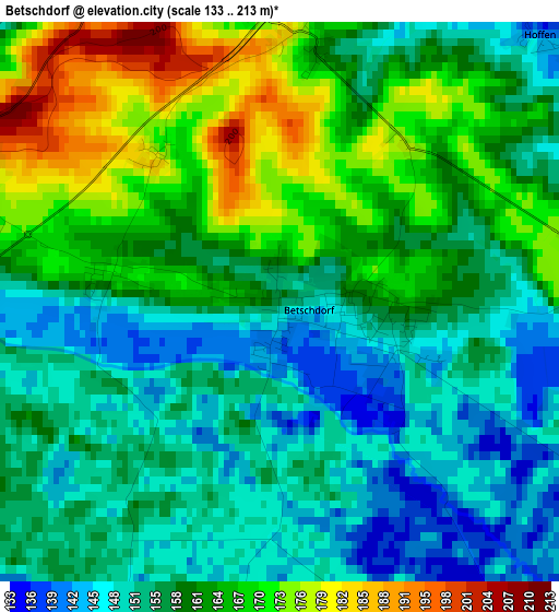
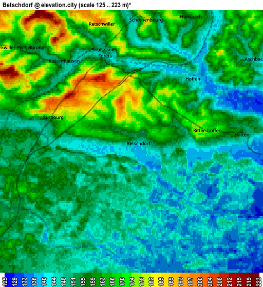
Below is the Elevation map of Betschdorf, which displays elevation range with different colors. Scale of the first map is from 133 to 213 m (436 to 699 ft) with average elevation of 159 meters (=522 ft) [note 1]
These maps also provides idea of topography and contour of this city, they are displayed at different zoom levels. More info about maps, scale and edge coordinates you can find below images.
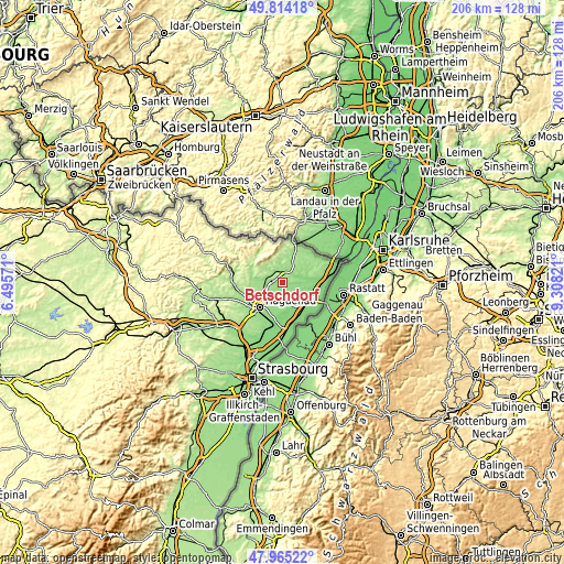
| \ | Map #1 | Map #2 | Topo.Map |
| Scale [m] | 133..213 m | 125..223 m | × |
| Scale [ft] | 436..699 ft | 410..732 ft | × |
| Average | 159 m = 522 ft | 154.5 m = 507 ft | × |
| Width | 6.42 km = 4 mi | 12.85 km = 8 mi | 205.6 km = 127.8 mi |
| Height | 6.42 km = 4 mi | 12.85 km = 8 mi | 205.6 km = 127.8 mi |
| ↑Max Latitude | 48.927131° | 48.955996° | 49.81418° |
| Latitude at center | 48.89825° | 48.89825° | 48.89825° |
| ↓Min Latitude | 48.869352° | 48.840437° | 47.96522° |
| ← Min Longitude | 7.858015° | 7.814069° | 6.49571° |
| Longitude center | 7.90196° | 7.90196° | 7.90196° |
| →Max Longitude | 7.945905° | 7.989851° | 9.30821° |
Nearby cities:
Cities around Betschdorf sort by population:
• Haguenau elevation 144 m
12.3 km,  221°
221°
• Soufflenheim 129 m
8.8 km,  149°
149°
• Soultz-sous-Forêts 150 m
4.6 km,  340°
340°
• Schirrhein 135 m
10.7 km,  178°
178°
• Roeschwoog 119 m
12.7 km,  128°
128°
• Hatten 151 m
5.7 km,  86°
86°
• Woerth 171 m
12.5 km,  291°
291°
• Surbourg 186 m
4.2 km, 288°
• Walbourg 168 m
8.4 km,  260°
260°
• Gœrsdorf 205 m
11.4 km,  300°
300°
• Durrenbach 171 m
9.8 km,  269°
269°
• Eschbach 187 m
12.4 km, 257°
Multilingual:
 En español:
Betschdorf elevación 145 m.
 En France:
Betschdorf élévation 145 m.
 Auf Deutsch:
Betschdorf höhe über dem Meeresspiegel ist 145 m.

Sources and notes:
- [note 1] Map square and city borders are not equal. Map elevation data is calculated only from area inside that square.
- [src 1] Elevation data from geonames database provided with same terms of usage.
- [src 2] The elevation map of Betschdorf is generated using elevation data from NASA's 3 arcsec (90m) resolution SRTM data.
- [src 3] Base (background) map © OpenStreetMap contributors tiles are generated by Geofabrik and OpenTopoMap.
Copyright & License:
This Betschdorf Elevation Map is licensed under CC BY-SA. You may reuse any part from this page, if you give a proper credit by linking to this URL:
 More info on terms of use page.