Soufflenheim elevation
Soufflenheim (Grand Est, Bas-Rhin), France elevation is 129 meters and Soufflenheim elevation in feet is 423 ft above sea level [src 1]. Soufflenheim is a populated place (feature code) with elevation that is 45 meters (148 ft) smaller than average city elevation in France.
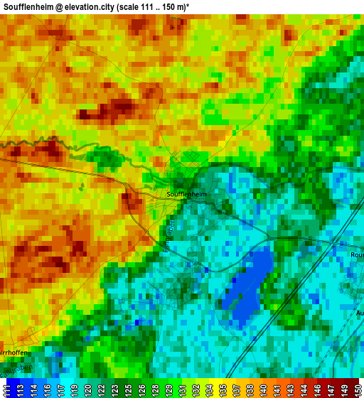
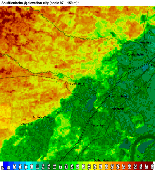
Below is the Elevation map of Soufflenheim, which displays elevation range with different colors. Scale of the first map is from 111 to 150 m (364 to 492 ft) with average elevation of 129 meters (=423 ft) [note 1]
These maps also provides idea of topography and contour of this city, they are displayed at different zoom levels. More info about maps, scale and edge coordinates you can find below images.
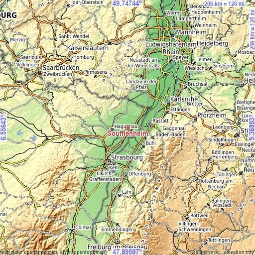
| \ | Map #1 | Map #2 | Topo.Map |
| Scale [m] | 111..150 m | 97..159 m | × |
| Scale [ft] | 364..492 ft | 318..522 ft | × |
| Average | 129 m = 423 ft | 129.4 m = 425 ft | × |
| Width | 6.43 km = 4 mi | 12.87 km = 8 mi | 205.9 km = 127.9 mi |
| Height | 6.43 km = 4 mi | 12.87 km = 8 mi | 205.8 km = 127.9 mi |
| ↑Max Latitude | 48.85918° | 48.888084° | 49.74744° |
| Latitude at center | 48.83026° | 48.83026° | 48.83026° |
| ↓Min Latitude | 48.801323° | 48.772369° | 47.89597° |
| ← Min Longitude | 7.918735° | 7.874789° | 6.55643° |
| Longitude center | 7.96268° | 7.96268° | 7.96268° |
| →Max Longitude | 8.006625° | 8.050571° | 9.36893° |
Nearby cities:
Cities around Soufflenheim sort by population:
• Haguenau elevation 144 m
12.7 km,  262°
262°
• Bischwiller 130 m
10.5 km,  229°
229°
• Drusenheim 123 m
7.6 km,  185°
185°
• Herrlisheim 125 m
11.9 km,  200°
200°
• Betschdorf 145 m
8.8 km,  329°
329°
• Oberhoffen-sur-Moder 137 m
8.9 km, 234°
• Schirrhein 135 m
5.2 km, 232°
• Roeschwoog 119 m
5.4 km,  94°
94°
• Sessenheim 120 m
4.2 km,  154°
154°
• Kaltenhouse 146 m
10.5 km,  245°
245°
• Hatten 151 m
8 km,  8°
8°
• Surbourg 186 m
12.3 km,  316°
316°
Multilingual:
 En español:
Soufflenheim elevación 129 m.
 En France:
Soufflenheim élévation 129 m.
 Auf Deutsch:
Soufflenheim höhe über dem Meeresspiegel ist 129 m.

Sources and notes:
- [note 1] Map square and city borders are not equal. Map elevation data is calculated only from area inside that square.
- [src 1] Elevation data from geonames database provided with same terms of usage.
- [src 2] The elevation map of Soufflenheim is generated using elevation data from NASA's 3 arcsec (90m) resolution SRTM data.
- [src 3] Base (background) map © OpenStreetMap contributors tiles are generated by Geofabrik and OpenTopoMap.
Copyright & License:
This Soufflenheim Elevation Map is licensed under CC BY-SA. You may reuse any part from this page, if you give a proper credit by linking to this URL:
 More info on terms of use page.