Paris elevation
Paris (Île-de-France), France elevation is 42 meters and Paris elevation in feet is 138 ft above sea level [src 1]. Paris is a capital of a political entity (feature code) with elevation that is 132 meters (433 ft) smaller than average city elevation in France.
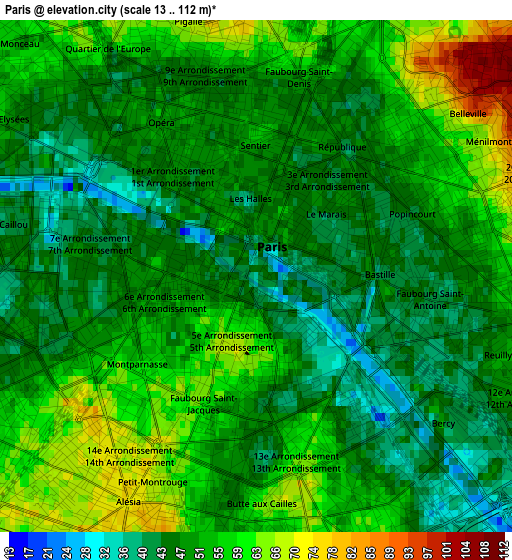
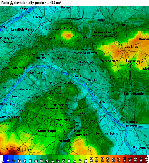
Below is the Elevation map of Paris, which displays elevation range with different colors. Scale of the first map is from 13 to 112 m (43 to 367 ft) with average elevation of 51.4 meters (=169 ft) [note 1]
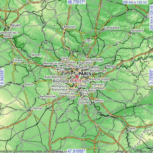
These maps also provides idea of topography and contour of this city, they are displayed at different zoom levels. More info about maps, scale and edge coordinates you can find below images.
| \ | Map #1 | Map #2 | Topo.Map |
| Scale [m] | 13..112 m | 4..169 m | × |
| Scale [ft] | 43..367 ft | 13..554 ft | × |
| Average | 51.4 m = 169 ft | 57.6 m = 189 ft | × |
| Width | 6.43 km = 4 mi | 12.86 km = 8 mi | 205.8 km = 127.9 mi |
| Height | 6.43 km = 4 mi | 12.86 km = 8 mi | 205.8 km = 127.9 mi |
| ↑Max Latitude | 48.882317° | 48.911208° | 49.77017° |
| Latitude at center | 48.85341° | 48.85341° | 48.85341° |
| ↓Min Latitude | 48.824486° | 48.795546° | 47.91955° |
| ← Min Longitude | 2.304855° | 2.260909° | 0.94255° |
| Longitude center | 2.3488° | 2.3488° | 2.3488° |
| →Max Longitude | 2.392745° | 2.436691° | 3.75505° |
Nearby cities:
Cities around Paris sort by population:
• Ivry-sur-Seine elevation 36 m
5 km,  147°
147°
• Clichy 35 m
5.9 km,  331°
331°
• Montrouge 71 m
4.9 km,  211°
211°
• Bagnolet 82 m
5.2 km,  73°
73°
• Charenton-le-Pont 53 m
5.8 km,  126°
126°
• Malakoff 69 m
5.2 km,  223°
223°
• Le Kremlin-Bicêtre 66 m
4.4 km,  168°
168°
• Vanves 64 m
5.4 km,  232°
232°
• Saint-Mandé 57 m
5.2 km,  108°
108°
• Les Lilas 122 m
6 km,  60°
60°
• Le Pré-Saint-Gervais 65 m
5.4 km,  48°
48°
• Gentilly 66 m
4.5 km,  186°
186°
Multilingual:
 En español:
París elevación 42 m.
 En France:
Paris élévation 42 m.


Sources and notes:
- [note 1] Map square and city borders are not equal. Map elevation data is calculated only from area inside that square.
- [src 1] Elevation data from geonames database provided with same terms of usage.
- [src 2] The elevation map of Paris is generated using elevation data from NASA's 3 arcsec (90m) resolution SRTM data.
- [src 3] Base (background) map © OpenStreetMap contributors tiles are generated by Geofabrik and OpenTopoMap.
Copyright & License:
This Paris Elevation Map is licensed under CC BY-SA. You may reuse any part from this page, if you give a proper credit by linking to this URL:
 More info on terms of use page.