Charenton-le-Pont elevation
Charenton-le-Pont (Île-de-France, Val-de-Marne), France elevation is 53 meters and Charenton-le-Pont elevation in feet is 174 ft above sea level [src 1]. Charenton-le-Pont is a populated place (feature code) with elevation that is 121 meters (397 ft) smaller than average city elevation in France.
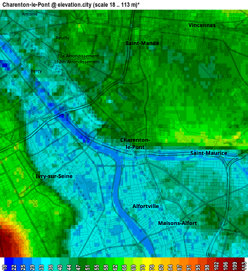
Below is the Elevation map of Charenton-le-Pont, which displays elevation range with different colors. Scale of the first map is from 18 to 113 m (59 to 371 ft) with average elevation of 46.5 meters (=153 ft) [note 1]
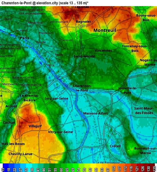
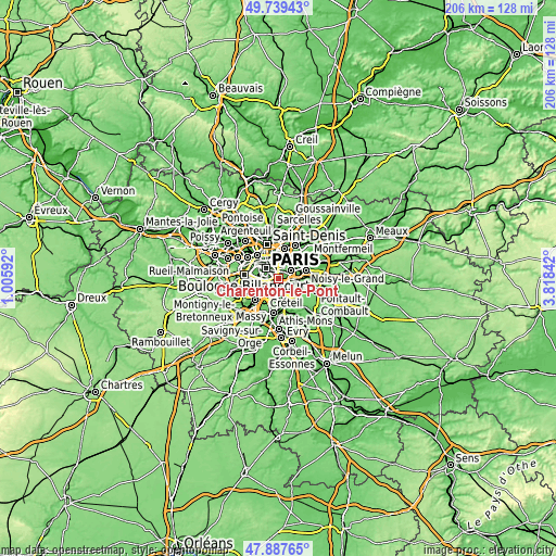
These maps also provides idea of topography and contour of this city, they are displayed at different zoom levels. More info about maps, scale and edge coordinates you can find below images.
| \ | Map #1 | Map #2 | Topo.Map |
| Scale [m] | 18..113 m | 13..135 m | × |
| Scale [ft] | 59..371 ft | 43..443 ft | × |
| Average | 46.5 m = 153 ft | 59.4 m = 195 ft | × |
| Width | 6.43 km = 4 mi | 12.87 km = 8 mi | 205.9 km = 127.9 mi |
| Height | 6.43 km = 4 mi | 12.87 km = 8 mi | 205.9 km = 127.9 mi |
| ↑Max Latitude | 48.851015° | 48.879924° | 49.73943° |
| Latitude at center | 48.82209° | 48.82209° | 48.82209° |
| ↓Min Latitude | 48.793148° | 48.764189° | 47.88765° |
| ← Min Longitude | 2.368225° | 2.324279° | 1.00592° |
| Longitude center | 2.41217° | 2.41217° | 2.41217° |
| →Max Longitude | 2.456115° | 2.500061° | 3.81842° |
Nearby cities:
Cities around Charenton-le-Pont sort by population:
• Créteil elevation 35 m
5.1 km,  129°
129°
• Vitry-sur-Seine 32 m
3.9 km,  189°
189°
• Ivry-sur-Seine 36 m
2.1 km,  250°
250°
• Maisons-Alfort 40 m
2.3 km,  120°
120°
• Villejuif 110 m
4.9 km,  230°
230°
• Vincennes 57 m
3.5 km,  32°
32°
• Alfortville 36 m
1.9 km,  161°
161°
• Bagnolet 82 m
5 km,  3°
3°
• Le Kremlin-Bicêtre 66 m
3.9 km,  257°
257°
• Saint-Mandé 57 m
1.9 km,  8°
8°
• Joinville-le-Pont 40 m
4.6 km,  85°
85°
• Saint-Maurice 60 m
1.1 km, 91°
Multilingual:
 En español:
Charenton-le-Pont elevación 53 m.
 En France:
Charenton-le-Pont élévation 53 m.
 Auf Deutsch:
Charenton-le-Pont höhe über dem Meeresspiegel ist 53 m.

Sources and notes:
- [note 1] Map square and city borders are not equal. Map elevation data is calculated only from area inside that square.
- [src 1] Elevation data from geonames database provided with same terms of usage.
- [src 2] The elevation map of Charenton-le-Pont is generated using elevation data from NASA's 3 arcsec (90m) resolution SRTM data.
- [src 3] Base (background) map © OpenStreetMap contributors tiles are generated by Geofabrik and OpenTopoMap.
Copyright & License:
This Charenton-le-Pont Elevation Map is licensed under CC BY-SA. You may reuse any part from this page, if you give a proper credit by linking to this URL:
 More info on terms of use page.