Pernes-les-Fontaines elevation
Pernes-les-Fontaines (Provence-Alpes-Côte d'Azur, Département du Vaucluse), France elevation is 102 meters and Pernes-les-Fontaines elevation in feet is 335 ft above sea level [src 1]. Pernes-les-Fontaines is a populated place (feature code) with elevation that is 72 meters (236 ft) smaller than average city elevation in France.
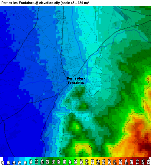
Below is the Elevation map of Pernes-les-Fontaines, which displays elevation range with different colors. Scale of the first map is from 45 to 339 m (148 to 1112 ft) with average elevation of 105.9 meters (=347 ft) [note 1]
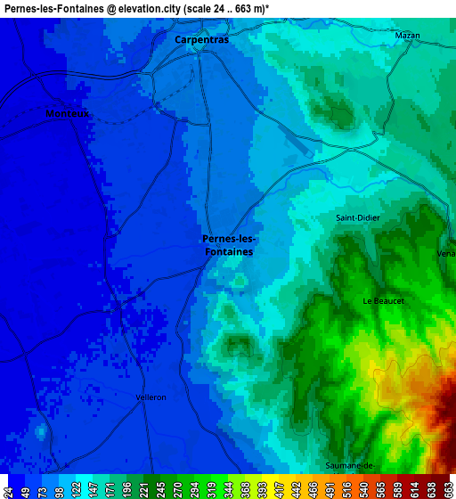
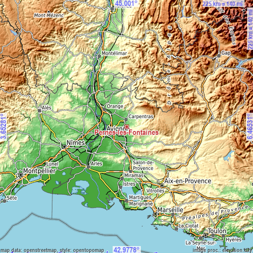
These maps also provides idea of topography and contour of this city, they are displayed at different zoom levels. More info about maps, scale and edge coordinates you can find below images.
| \ | Map #1 | Map #2 | Topo.Map |
| Scale [m] | 45..339 m | 24..663 m | × |
| Scale [ft] | 148..1112 ft | 79..2175 ft | × |
| Average | 105.9 m = 347 ft | 130.5 m = 428 ft | × |
| Width | 7.03 km = 4.4 mi | 14.06 km = 8.7 mi | 225 km = 139.8 mi |
| Height | 7.03 km = 4.4 mi | 14.06 km = 8.7 mi | 224.9 km = 139.7 mi |
| ↑Max Latitude | 44.029624° | 44.061212° | 45.001° |
| Latitude at center | 43.99802° | 43.99802° | 43.99802° |
| ↓Min Latitude | 43.966399° | 43.934761° | 42.9778° |
| ← Min Longitude | 5.015115° | 4.971169° | 3.65281° |
| Longitude center | 5.05906° | 5.05906° | 5.05906° |
| →Max Longitude | 5.103005° | 5.146951° | 6.46531° |
Nearby cities:
Cities around Pernes-les-Fontaines sort by population:
• Carpentras elevation 90 m
6.4 km,  352°
352°
• L’Isle-sur-la-Sorgue 66 m
8.7 km,  184°
184°
• Monteux 49 m
6.6 km,  310°
310°
• Entraigues-sur-la-Sorgue 27 m
10.6 km,  273°
273°
• Le Thor 53 m
9.2 km,  213°
213°
• Mazan 154 m
8.5 km,  39°
39°
• Velleron 65 m
5.1 km, 207°
• Althen-des-Paluds 33 m
8.1 km, 274°
• Loriol-du-Comtat 47 m
9.9 km,  331°
331°
• Saint-Didier 171 m
4.2 km,  80°
80°
• Malemort-du-Comtat 219 m
8.4 km,  72°
72°
• Venasque 240 m
7 km,  91°
91°
Multilingual:
 En español:
Pernes-les-Fontaines elevación 102 m.
 En France:
Pernes-les-Fontaines élévation 102 m.
 Auf Deutsch:
Pernes-les-Fontaines höhe über dem Meeresspiegel ist 102 m.

Sources and notes:
- [note 1] Map square and city borders are not equal. Map elevation data is calculated only from area inside that square.
- [src 1] Elevation data from geonames database provided with same terms of usage.
- [src 2] The elevation map of Pernes-les-Fontaines is generated using elevation data from NASA's 3 arcsec (90m) resolution SRTM data.
- [src 3] Base (background) map © OpenStreetMap contributors tiles are generated by Geofabrik and OpenTopoMap.
Copyright & License:
This Pernes-les-Fontaines Elevation Map is licensed under CC BY-SA. You may reuse any part from this page, if you give a proper credit by linking to this URL:
 More info on terms of use page.