Pfetterhouse elevation
Pfetterhouse (Grand Est, Haut-Rhin), France elevation is 437 meters and Pfetterhouse elevation in feet is 1434 ft above sea level [src 1]. Pfetterhouse is a populated place (feature code) with elevation that is 263 meters (863 ft) bigger than average city elevation in France.
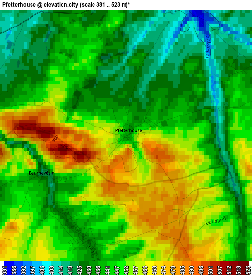
Below is the Elevation map of Pfetterhouse, which displays elevation range with different colors. Scale of the first map is from 381 to 523 m (1250 to 1716 ft) with average elevation of 445.8 meters (=1463 ft) [note 1]
These maps also provides idea of topography and contour of this city, they are displayed at different zoom levels. More info about maps, scale and edge coordinates you can find below images.
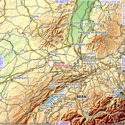
| \ | Map #1 | Topo.Map |
| Scale [m] | 381..523 m | × |
| Scale [ft] | 1250..1716 ft | × |
| Average | 445.8 m = 1463 ft | × |
| Width | 6.6 km = 4.1 mi | 211.3 km = 131.3 mi |
| Height | 6.6 km = 4.1 mi | 211.3 km = 131.3 mi |
| ↑Max Latitude | 47.53096° | 48.44272° |
| Latitude at center | 47.50128° | 47.50128° |
| ↓Min Latitude | 47.471583° | 46.54265° |
| ← Min Longitude | 7.122035° | 5.75973° |
| Longitude center | 7.16598° | 7.16598° |
| →Max Longitude | 7.209925° | 8.57223° |
Nearby cities:
Cities around Pfetterhouse sort by population:
• Delle elevation 374 m
12.5 km,  273°
273°
• Altkirch 340 m
14.7 km,  21°
21°
• Grandvillars 355 m
15.2 km,  286°
286°
• Hirsingue 328 m
11.6 km,  34°
34°
• Dannemarie 315 m
14.8 km,  346°
346°
• Carspach 320 m
13.2 km,  14°
14°
• Joncherey 384 m
12.6 km,  284°
284°
• Waldighofen 389 m
12.5 km,  63°
63°
• Hirtzbach 318 m
11.6 km, 21°
• Ferrette 515 m
11.1 km,  93°
93°
• Aspach 298 m
16.5 km, 17°
• Montreux-Château 342 m
17.4 km,  314°
314°
Multilingual:
 En español:
Pfetterhouse elevación 437 m.
 En France:
Pfetterhouse élévation 437 m.
 Auf Deutsch:
Pfetterhouse höhe über dem Meeresspiegel ist 437 m.

Sources and notes:
- [note 1] Map square and city borders are not equal. Map elevation data is calculated only from area inside that square.
- [src 1] Elevation data from geonames database provided with same terms of usage.
- [src 2] The elevation map of Pfetterhouse is generated using elevation data from NASA's 3 arcsec (90m) resolution SRTM data.
- [src 3] Base (background) map © OpenStreetMap contributors tiles are generated by Geofabrik and OpenTopoMap.
Copyright & License:
This Pfetterhouse Elevation Map is licensed under CC BY-SA. You may reuse any part from this page, if you give a proper credit by linking to this URL:
 More info on terms of use page.