Montreux-Château elevation
Montreux-Château (Bourgogne-Franche-Comté, Territoire de Belfort), France elevation is 342 meters and Montreux-Château elevation in feet is 1122 ft above sea level [src 1]. Montreux-Château is a populated place (feature code) with elevation that is 168 meters (551 ft) bigger than average city elevation in France.
Below is the Elevation map of Montreux-Château, which displays elevation range with different colors. Scale of the first map is from 329 to 388 m (1079 to 1273 ft) with average elevation of 353.4 meters (=1159 ft) [note 1]
These maps also provides idea of topography and contour of this city, they are displayed at different zoom levels. More info about maps, scale and edge coordinates you can find below images.
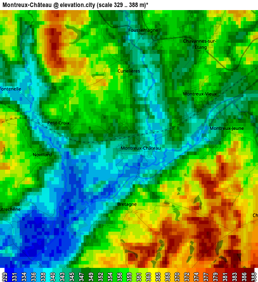
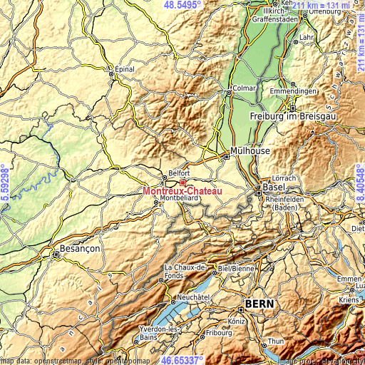
| \ | Map #1 | Topo.Map |
| Scale [m] | 329..388 m | × |
| Scale [ft] | 1079..1273 ft | × |
| Average | 353.4 m = 1159 ft | × |
| Width | 6.59 km = 4.1 mi | 210.8 km = 131 mi |
| Height | 6.59 km = 4.1 mi | 210.8 km = 131 mi |
| ↑Max Latitude | 47.639648° | 48.5495° |
| Latitude at center | 47.61003° | 47.61003° |
| ↓Min Latitude | 47.580395° | 46.65337° |
| ← Min Longitude | 6.955285° | 5.59298° |
| Longitude center | 6.99923° | 6.99923° |
| →Max Longitude | 7.043175° | 8.40548° |
Nearby cities:
Cities around Montreux-Château sort by population:
• Belfort elevation 363 m
11.5 km,  288°
288°
• Delle 374 m
11.3 km,  179°
179°
• Offemont 378 m
10.8 km,  302°
302°
• Danjoutin 367 m
10.3 km,  275°
275°
• Grandvillars 355 m
8.1 km,  195°
195°
• Bourogne 348 m
8.1 km,  229°
229°
• Dannemarie 315 m
9.3 km,  75°
75°
• Joncherey 384 m
9 km, 178°
• Méziré 365 m
10.4 km,  214°
214°
• Chèvremont 348 m
6.3 km, 289°
• Andelnans 347 m
10 km,  265°
265°
• Morvillars 333 m
8.4 km,  215°
215°
Multilingual:
 En español:
Montreux-Château elevación 342 m.
 En France:
Montreux-Château élévation 342 m.
 Auf Deutsch:
Montreux-Château höhe über dem Meeresspiegel ist 342 m.

Sources and notes:
- [note 1] Map square and city borders are not equal. Map elevation data is calculated only from area inside that square.
- [src 1] Elevation data from geonames database provided with same terms of usage.
- [src 2] The elevation map of Montreux-Château is generated using elevation data from NASA's 3 arcsec (90m) resolution SRTM data.
- [src 3] Base (background) map © OpenStreetMap contributors tiles are generated by Geofabrik and OpenTopoMap.
Copyright & License:
This Montreux-Château Elevation Map is licensed under CC BY-SA. You may reuse any part from this page, if you give a proper credit by linking to this URL:
 More info on terms of use page.