Pont-de-Chéruy elevation
Pont-de-Chéruy (Auvergne-Rhône-Alpes, Département de l'Isère), France elevation is 202 meters and Pont-de-Chéruy elevation in feet is 663 ft above sea level [src 1]. Pont-de-Chéruy is a populated place (feature code) with elevation that is 28 meters (92 ft) bigger than average city elevation in France.
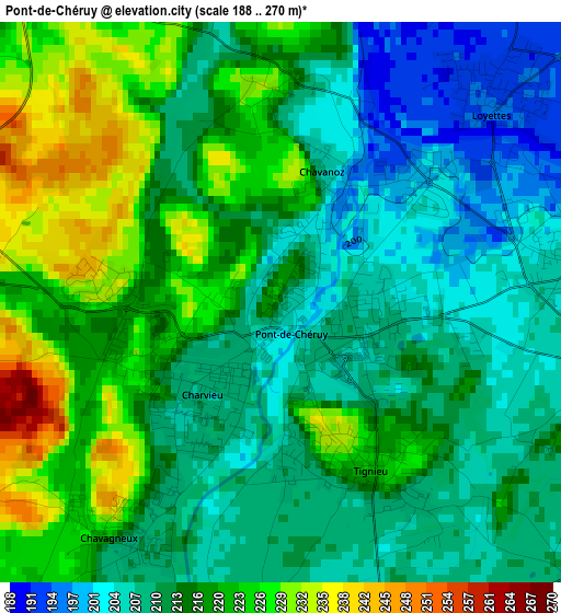
Below is the Elevation map of Pont-de-Chéruy, which displays elevation range with different colors. Scale of the first map is from 188 to 270 m (617 to 886 ft) with average elevation of 214.8 meters (=705 ft) [note 1]
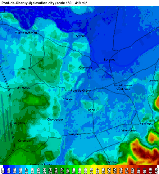
These maps also provides idea of topography and contour of this city, they are displayed at different zoom levels. More info about maps, scale and edge coordinates you can find below images.
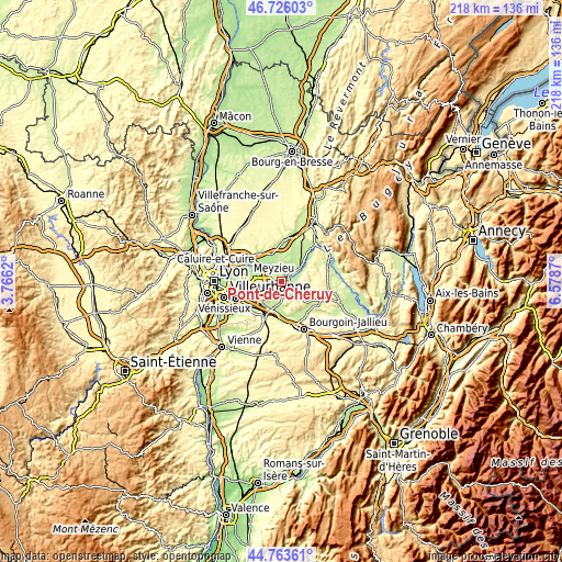
| \ | Map #1 | Map #2 | Topo.Map |
| Scale [m] | 188..270 m | 180..419 m | × |
| Scale [ft] | 617..886 ft | 591..1375 ft | × |
| Average | 214.8 m = 705 ft | 221.6 m = 727 ft | × |
| Width | 6.82 km = 4.2 mi | 13.64 km = 8.5 mi | 218.2 km = 135.6 mi |
| Height | 6.82 km = 4.2 mi | 13.64 km = 8.5 mi | 218.2 km = 135.6 mi |
| ↑Max Latitude | 45.784094° | 45.814732° | 46.72603° |
| Latitude at center | 45.75344° | 45.75344° | 45.75344° |
| ↓Min Latitude | 45.722769° | 45.692081° | 44.76361° |
| ← Min Longitude | 5.128505° | 5.084559° | 3.7662° |
| Longitude center | 5.17245° | 5.17245° | 5.17245° |
| →Max Longitude | 5.216395° | 5.260341° | 6.5787° |
Nearby cities:
Cities around Pont-de-Chéruy sort by population:
• Charvieu-Chavagneux elevation 226 m
1.8 km,  257°
257°
• Tignieu 205 m
1.3 km,  98°
98°
• Chavanoz 196 m
2.1 km,  35°
35°
• Crémieu 222 m
6.7 km,  117°
117°
• Pusignan 215 m
8.2 km,  271°
271°
• Saint-Romain-de-Jalionas 210 m
3.5 km,  83°
83°
• Loyettes 194 m
3.7 km,  45°
45°
• Saint-Maurice-de-Gourdans 205 m
7.9 km,  12°
12°
• Satolas-et-Bonce 233 m
7.4 km,  206°
206°
• Villemoirieu 212 m
5.7 km,  132°
132°
• Chamagnieu 294 m
7.9 km,  181°
181°
• Janneyrias 240 m
4.6 km, 268°
Multilingual:
 En español:
Pont-de-Chéruy elevación 202 m.
 En France:
Pont-de-Chéruy élévation 202 m.
 Auf Deutsch:
Pont-de-Chéruy höhe über dem Meeresspiegel ist 202 m.

Sources and notes:
- [note 1] Map square and city borders are not equal. Map elevation data is calculated only from area inside that square.
- [src 1] Elevation data from geonames database provided with same terms of usage.
- [src 2] The elevation map of Pont-de-Chéruy is generated using elevation data from NASA's 3 arcsec (90m) resolution SRTM data.
- [src 3] Base (background) map © OpenStreetMap contributors tiles are generated by Geofabrik and OpenTopoMap.
Copyright & License:
This Pont-de-Chéruy Elevation Map is licensed under CC BY-SA. You may reuse any part from this page, if you give a proper credit by linking to this URL:
 More info on terms of use page.