Québriac elevation
Québriac (Brittany, Département d'Ille-et-Vilaine), France elevation is 49 meters and Québriac elevation in feet is 161 ft above sea level [src 1]. Québriac is a populated place (feature code) with elevation that is 125 meters (410 ft) smaller than average city elevation in France.
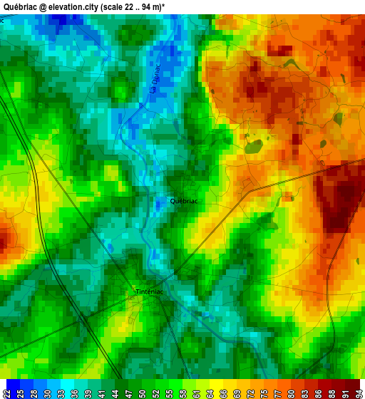
Below is the Elevation map of Québriac, which displays elevation range with different colors. Scale of the first map is from 22 to 94 m (72 to 308 ft) with average elevation of 55.3 meters (=181 ft) [note 1]
These maps also provides idea of topography and contour of this city, they are displayed at different zoom levels. More info about maps, scale and edge coordinates you can find below images.
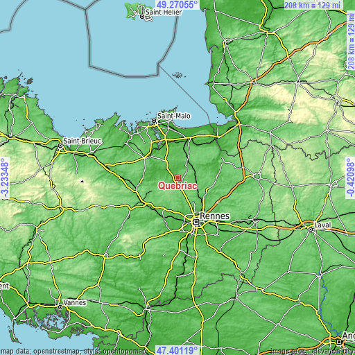
| \ | Map #1 | Topo.Map |
| Scale [m] | 22..94 m | × |
| Scale [ft] | 72..308 ft | × |
| Average | 55.3 m = 181 ft | × |
| Width | 6.5 km = 4 mi | 207.9 km = 129.2 mi |
| Height | 6.5 km = 4 mi | 207.8 km = 129.1 mi |
| ↑Max Latitude | 48.37364° | 49.27055° |
| Latitude at center | 48.34444° | 48.34444° |
| ↓Min Latitude | 48.315223° | 47.40119° |
| ← Min Longitude | -1.871175° | -3.23348° |
| Longitude center | -1.82723° | -1.82723° |
| →Max Longitude | -1.783285° | -0.42098° |
Nearby cities:
Cities around Québriac sort by population:
• Combourg elevation 60 m
9.8 km,  38°
38°
• Tinténiac 56 m
1.9 km,  200°
200°
• Saint-Pierre-de-Plesguen 83 m
13 km,  330°
330°
• Hédé-Bazouges 52 m
5.3 km,  157°
157°
• Montreuil-sur-Ille 57 m
12.4 km,  109°
109°
• Saint-Domineuc 37 m
4.7 km,  310°
310°
• Évran 21 m
12 km,  289°
289°
• Guipel 75 m
9.5 km,  121°
121°
• Meillac 43 m
7.5 km,  7°
7°
• Dingé 89 m
8.4 km,  80°
80°
• Pleugueneuc 64 m
8.1 km,  316°
316°
• Vignoc 97 m
11.2 km, 162°
Multilingual:
 En español:
Québriac elevación 49 m.
 En France:
Québriac élévation 49 m.


Sources and notes:
- [note 1] Map square and city borders are not equal. Map elevation data is calculated only from area inside that square.
- [src 1] Elevation data from geonames database provided with same terms of usage.
- [src 2] The elevation map of Québriac is generated using elevation data from NASA's 3 arcsec (90m) resolution SRTM data.
- [src 3] Base (background) map © OpenStreetMap contributors tiles are generated by Geofabrik and OpenTopoMap.
Copyright & License:
This Québriac Elevation Map is licensed under CC BY-SA. You may reuse any part from this page, if you give a proper credit by linking to this URL:
 More info on terms of use page.