Richelieu elevation
Richelieu (Centre, Département d'Indre-et-Loire), France elevation is 56 meters and Richelieu elevation in feet is 184 ft above sea level [src 1]. Richelieu is a populated place (feature code) with elevation that is 118 meters (387 ft) smaller than average city elevation in France.
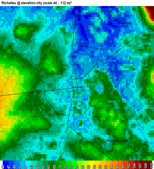
Below is the Elevation map of Richelieu, which displays elevation range with different colors. Scale of the first map is from 44 to 112 m (144 to 367 ft) with average elevation of 61.7 meters (=202 ft) [note 1]
These maps also provides idea of topography and contour of this city, they are displayed at different zoom levels. More info about maps, scale and edge coordinates you can find below images.
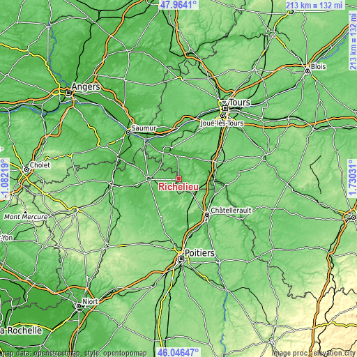
| \ | Map #1 | Topo.Map |
| Scale [m] | 44..112 m | × |
| Scale [ft] | 144..367 ft | × |
| Average | 61.7 m = 202 ft | × |
| Width | 6.66 km = 4.1 mi | 213.2 km = 132.5 mi |
| Height | 6.66 km = 4.1 mi | 213.2 km = 132.5 mi |
| ↑Max Latitude | 47.043844° | 47.9641° |
| Latitude at center | 47.01389° | 47.01389° |
| ↓Min Latitude | 46.983919° | 46.04647° |
| ← Min Longitude | 0.280115° | -1.08219° |
| Longitude center | 0.32406° | 0.32406° |
| →Max Longitude | 0.368005° | 1.73031° |
Nearby cities:
Cities around Richelieu sort by population:
• Chinon elevation 86 m
18.1 km,  340°
340°
• Loudun 95 m
18.3 km,  267°
267°
• Dangé-Saint-Romain 42 m
22.8 km,  113°
113°
• Beaumont-en-Véron 41 m
22.6 km,  332°
332°
• Thuré 83 m
22.7 km,  153°
153°
• Lencloître 75 m
22.2 km,  179°
179°
• L'Île-Bouchard 38 m
13.4 km,  31°
31°
• Les Ormes 70 m
21.9 km,  102°
102°
• Saint-Épain 58 m
21.7 km,  47°
47°
• Saint-Gervais-les-Trois-Clochers 83 m
14.1 km, 153°
• La Celle-Saint-Avant 59 m
21.3 km,  87°
87°
• Ligré 53 m
11.5 km, 341°
Multilingual:
 En español:
Richelieu elevación 56 m.
 En France:
Richelieu élévation 56 m.
 Auf Deutsch:
Richelieu höhe über dem Meeresspiegel ist 56 m.

Sources and notes:
- [note 1] Map square and city borders are not equal. Map elevation data is calculated only from area inside that square.
- [src 1] Elevation data from geonames database provided with same terms of usage.
- [src 2] The elevation map of Richelieu is generated using elevation data from NASA's 3 arcsec (90m) resolution SRTM data.
- [src 3] Base (background) map © OpenStreetMap contributors tiles are generated by Geofabrik and OpenTopoMap.
Copyright & License:
This Richelieu Elevation Map is licensed under CC BY-SA. You may reuse any part from this page, if you give a proper credit by linking to this URL:
 More info on terms of use page.