Saint-Épain elevation
Saint-Épain (Centre, Département d'Indre-et-Loire), France elevation is 58 meters and Saint-Épain elevation in feet is 190 ft above sea level [src 1]. Saint-Épain is a populated place (feature code) with elevation that is 116 meters (381 ft) smaller than average city elevation in France.
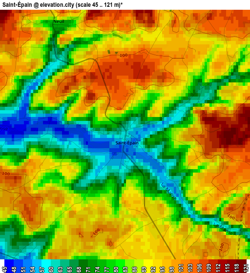
Below is the Elevation map of Saint-Épain, which displays elevation range with different colors. Scale of the first map is from 45 to 121 m (148 to 397 ft) with average elevation of 86.6 meters (=284 ft) [note 1]
These maps also provides idea of topography and contour of this city, they are displayed at different zoom levels. More info about maps, scale and edge coordinates you can find below images.
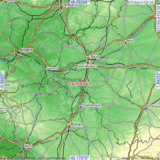
| \ | Map #1 | Topo.Map |
| Scale [m] | 45..121 m | × |
| Scale [ft] | 148..397 ft | × |
| Average | 86.6 m = 284 ft | × |
| Width | 6.65 km = 4.1 mi | 212.7 km = 132.2 mi |
| Height | 6.65 km = 4.1 mi | 212.7 km = 132.2 mi |
| ↑Max Latitude | 47.174701° | 48.09268° |
| Latitude at center | 47.14482° | 47.14482° |
| ↓Min Latitude | 47.114922° | 46.17975° |
| ← Min Longitude | 0.492735° | -0.86957° |
| Longitude center | 0.53668° | 0.53668° |
| →Max Longitude | 0.580625° | 1.94293° |
Nearby cities:
Cities around Saint-Épain sort by population:
• Monts elevation 57 m
16.2 km,  24°
24°
• Sainte-Maure-de-Touraine 78 m
7.5 km,  119°
119°
• Montbazon 66 m
19.7 km,  38°
38°
• Azay-le-Rideau 86 m
14.1 km,  339°
339°
• Artannes-sur-Indre 53 m
15.2 km, 18°
• Sorigny 97 m
16.2 km,  47°
47°
• L'Île-Bouchard 38 m
9.6 km,  250°
250°
• Cheillé 57 m
16.3 km,  322°
322°
• Manthelan 109 m
19.4 km,  92°
92°
• Thilouze 81 m
9.4 km, 20°
• La Celle-Saint-Avant 59 m
14.6 km,  159°
159°
• Saché 61 m
11.4 km,  2°
2°
Multilingual:
 En español:
Saint-Épain elevación 58 m.
 En France:
Saint-Épain élévation 58 m.
 Auf Deutsch:
Saint-Épain höhe über dem Meeresspiegel ist 58 m.

Sources and notes:
- [note 1] Map square and city borders are not equal. Map elevation data is calculated only from area inside that square.
- [src 1] Elevation data from geonames database provided with same terms of usage.
- [src 2] The elevation map of Saint-Épain is generated using elevation data from NASA's 3 arcsec (90m) resolution SRTM data.
- [src 3] Base (background) map © OpenStreetMap contributors tiles are generated by Geofabrik and OpenTopoMap.
Copyright & License:
This Saint-Épain Elevation Map is licensed under CC BY-SA. You may reuse any part from this page, if you give a proper credit by linking to this URL:
 More info on terms of use page.