Rimogne elevation
Rimogne (Grand Est, Ardennes), France elevation is 258 meters and Rimogne elevation in feet is 846 ft above sea level [src 1]. Rimogne is a populated place (feature code) with elevation that is 84 meters (276 ft) bigger than average city elevation in France.
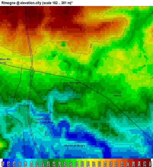
Below is the Elevation map of Rimogne, which displays elevation range with different colors. Scale of the first map is from 162 to 381 m (531 to 1250 ft) with average elevation of 258.1 meters (=847 ft) [note 1]
These maps also provides idea of topography and contour of this city, they are displayed at different zoom levels. More info about maps, scale and edge coordinates you can find below images.
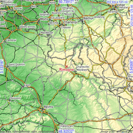
| \ | Map #1 | Topo.Map |
| Scale [m] | 162..381 m | × |
| Scale [ft] | 531..1250 ft | × |
| Average | 258.1 m = 847 ft | × |
| Width | 6.3 km = 3.9 mi | 201.7 km = 125.3 mi |
| Height | 6.3 km = 3.9 mi | 201.7 km = 125.3 mi |
| ↑Max Latitude | 49.869083° | 50.73917° |
| Latitude at center | 49.84075° | 49.84075° |
| ↓Min Latitude | 49.812401° | 48.92532° |
| ← Min Longitude | 4.495465° | 3.13316° |
| Longitude center | 4.53941° | 4.53941° |
| →Max Longitude | 4.583355° | 5.94566° |
Nearby cities:
Cities around Rimogne sort by population:
• Charleville-Mézières elevation 150 m
15.5 km,  121°
121°
• Revin 146 m
13 km,  31°
31°
• Nouzonville 153 m
15.2 km,  101°
101°
• Monthermé 141 m
14.5 km,  70°
70°
• Rocroi 384 m
9.6 km,  352°
352°
• Aiglemont 255 m
17.5 km,  112°
112°
• Montcy-Notre-Dame 165 m
16.3 km, 116°
• Warcq 146 m
12.5 km,  125°
125°
• Prix-lès-Mézières 144 m
14.4 km, 131°
• Renwez 278 m
4.6 km,  93°
93°
• Deville 147 m
12.7 km, 70°
• Tournes 164 m
8.6 km, 124°
Multilingual:
 En español:
Rimogne elevación 258 m.
 En France:
Rimogne élévation 258 m.


Sources and notes:
- [note 1] Map square and city borders are not equal. Map elevation data is calculated only from area inside that square.
- [src 1] Elevation data from geonames database provided with same terms of usage.
- [src 2] The elevation map of Rimogne is generated using elevation data from NASA's 3 arcsec (90m) resolution SRTM data.
- [src 3] Base (background) map © OpenStreetMap contributors tiles are generated by Geofabrik and OpenTopoMap.
Copyright & License:
This Rimogne Elevation Map is licensed under CC BY-SA. You may reuse any part from this page, if you give a proper credit by linking to this URL:
 More info on terms of use page.