Romorantin-Lanthenay elevation
Romorantin-Lanthenay (Centre, Département du Loir-et-Cher), France elevation is 95 meters and Romorantin-Lanthenay elevation in feet is 312 ft above sea level [src 1]. Romorantin-Lanthenay is a seat of a third-order administrative division (feature code) with elevation that is 79 meters (259 ft) smaller than average city elevation in France.
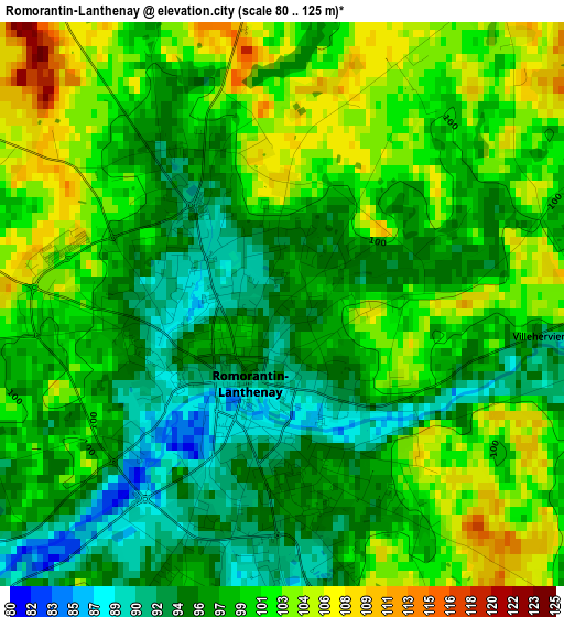
Below is the Elevation map of Romorantin-Lanthenay, which displays elevation range with different colors. Scale of the first map is from 80 to 125 m (262 to 410 ft) with average elevation of 98.8 meters (=324 ft) [note 1]
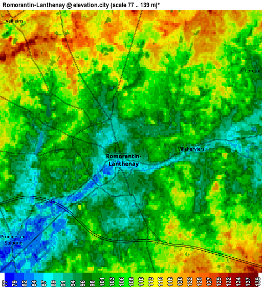
These maps also provides idea of topography and contour of this city, they are displayed at different zoom levels. More info about maps, scale and edge coordinates you can find below images.
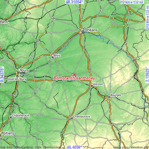
| \ | Map #1 | Map #2 | Topo.Map |
| Scale [m] | 80..125 m | 77..139 m | × |
| Scale [ft] | 262..410 ft | 253..456 ft | × |
| Average | 98.8 m = 324 ft | 103.8 m = 341 ft | × |
| Width | 6.62 km = 4.1 mi | 13.24 km = 8.2 mi | 211.8 km = 131.6 mi |
| Height | 6.62 km = 4.1 mi | 13.24 km = 8.2 mi | 211.8 km = 131.6 mi |
| ↑Max Latitude | 47.396426° | 47.426165° | 48.31054° |
| Latitude at center | 47.36667° | 47.36667° | 47.36667° |
| ↓Min Latitude | 47.336897° | 47.307108° | 46.4056° |
| ← Min Longitude | 1.706055° | 1.662109° | 0.34375° |
| Longitude center | 1.75° | 1.75° | 1.75° |
| →Max Longitude | 1.793945° | 1.837891° | 3.15625° |
Nearby cities:
Cities around Romorantin-Lanthenay sort by population:
• Selles-sur-Cher elevation 80 m
17.7 km,  236°
236°
• Chabris 86 m
14.6 km,  210°
210°
• Villefranche-sur-Cher 99 m
7.5 km,  170°
170°
• Pruniers-en-Sologne 80 m
8.4 km,  228°
228°
• Gièvres 93 m
11.5 km, 211°
• Châtillon-sur-Cher 111 m
21.8 km, 242°
• Soings-en-Sologne 111 m
17.7 km,  286°
286°
• Selles-Saint-Denis 97 m
13.2 km,  80°
80°
• Mur-de-Sologne 117 m
11.8 km,  295°
295°
• Châtres-sur-Cher 105 m
16.3 km,  133°
133°
• Neung-sur-Beuvron 99 m
19.2 km,  12°
12°
• La Ferté-Imbault 99 m
15.4 km, 82°
Multilingual:
 En español:
Romorantin-Lanthenay elevación 95 m.
 En France:
Romorantin élévation 95 m.
 Auf Deutsch:
Romorantin-Lanthenay höhe über dem Meeresspiegel ist 95 m.

Sources and notes:
- [note 1] Map square and city borders are not equal. Map elevation data is calculated only from area inside that square.
- [src 1] Elevation data from geonames database provided with same terms of usage.
- [src 2] The elevation map of Romorantin-Lanthenay is generated using elevation data from NASA's 3 arcsec (90m) resolution SRTM data.
- [src 3] Base (background) map © OpenStreetMap contributors tiles are generated by Geofabrik and OpenTopoMap.
Copyright & License:
This Romorantin-Lanthenay Elevation Map is licensed under CC BY-SA. You may reuse any part from this page, if you give a proper credit by linking to this URL:
 More info on terms of use page.