Rouffach elevation
Rouffach (Grand Est, Haut-Rhin), France elevation is 204 meters and Rouffach elevation in feet is 669 ft above sea level [src 1]. Rouffach is a populated place (feature code) with elevation that is 30 meters (98 ft) bigger than average city elevation in France.
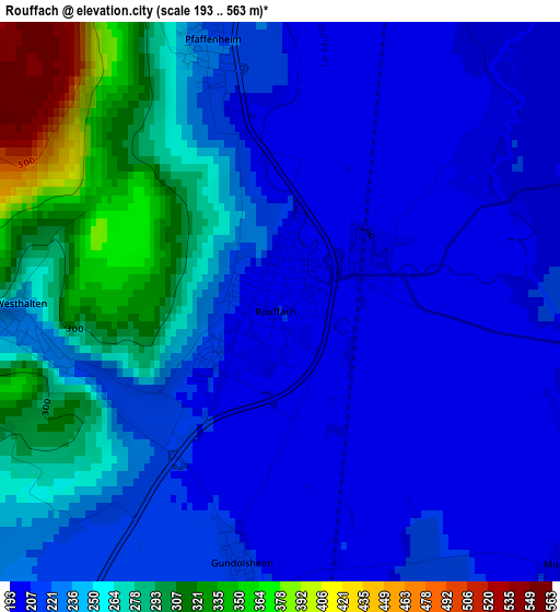
Below is the Elevation map of Rouffach, which displays elevation range with different colors. Scale of the first map is from 193 to 563 m (633 to 1847 ft) with average elevation of 240.8 meters (=790 ft) [note 1]
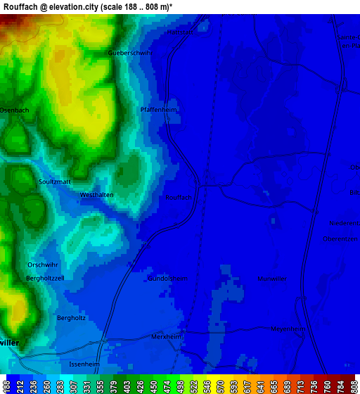
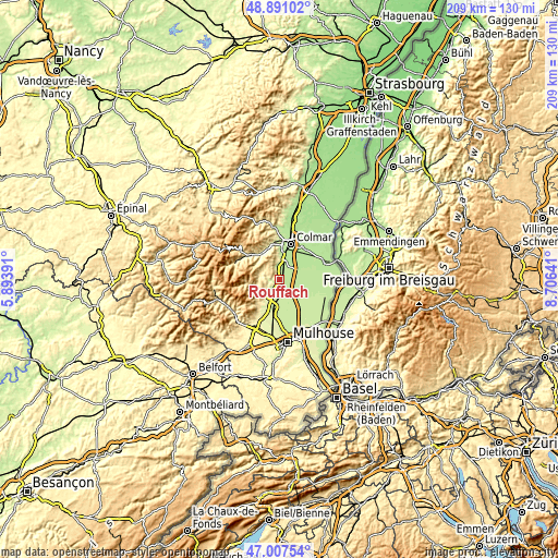
These maps also provides idea of topography and contour of this city, they are displayed at different zoom levels. More info about maps, scale and edge coordinates you can find below images.
| \ | Map #1 | Map #2 | Topo.Map |
| Scale [m] | 193..563 m | 188..808 m | × |
| Scale [ft] | 633..1847 ft | 617..2651 ft | × |
| Average | 240.8 m = 790 ft | 269.9 m = 885 ft | × |
| Width | 6.54 km = 4.1 mi | 13.09 km = 8.1 mi | 209.4 km = 130.1 mi |
| Height | 6.54 km = 4.1 mi | 13.09 km = 8.1 mi | 209.4 km = 130.1 mi |
| ↑Max Latitude | 47.987281° | 48.016685° | 48.89102° |
| Latitude at center | 47.95786° | 47.95786° | 47.95786° |
| ↓Min Latitude | 47.928422° | 47.898968° | 47.00754° |
| ← Min Longitude | 7.256215° | 7.212269° | 5.89391° |
| Longitude center | 7.30016° | 7.30016° | 7.30016° |
| →Max Longitude | 7.344105° | 7.388051° | 8.70641° |
Nearby cities:
Cities around Rouffach sort by population:
• Issenheim elevation 249 m
7 km,  210°
210°
• Sainte-Croix-en-Plaine 197 m
8.5 km,  48°
48°
• Soultzmatt 258 m
4.7 km,  275°
275°
• Réguisheim 212 m
8 km,  150°
150°
• Ungersheim 215 m
8.8 km,  176°
176°
• Herrlisheim-près-Colmar 193 m
7 km,  16°
16°
• Pfaffenheim 219 m
3.2 km,  345°
345°
• Merxheim 215 m
5.2 km, 184°
• Oberhergheim 202 m
7.1 km,  82°
82°
• Meyenheim 210 m
6.4 km,  139°
139°
• Raedersheim 226 m
7.8 km,  189°
189°
• Bergholtz 246 m
6.1 km,  221°
221°
Multilingual:
 En español:
Rouffach elevación 204 m.
 En France:
Rouffach élévation 204 m.
 Auf Deutsch:
Rouffach höhe über dem Meeresspiegel ist 204 m.

Sources and notes:
- [note 1] Map square and city borders are not equal. Map elevation data is calculated only from area inside that square.
- [src 1] Elevation data from geonames database provided with same terms of usage.
- [src 2] The elevation map of Rouffach is generated using elevation data from NASA's 3 arcsec (90m) resolution SRTM data.
- [src 3] Base (background) map © OpenStreetMap contributors tiles are generated by Geofabrik and OpenTopoMap.
Copyright & License:
This Rouffach Elevation Map is licensed under CC BY-SA. You may reuse any part from this page, if you give a proper credit by linking to this URL:
 More info on terms of use page.