Rugles elevation
Rugles (Normandy, Département de l'Eure), France elevation is 181 meters and Rugles elevation in feet is 594 ft above sea level [src 1]. Rugles is a populated place (feature code) with elevation that is 7 meters (23 ft) bigger than average city elevation in France.
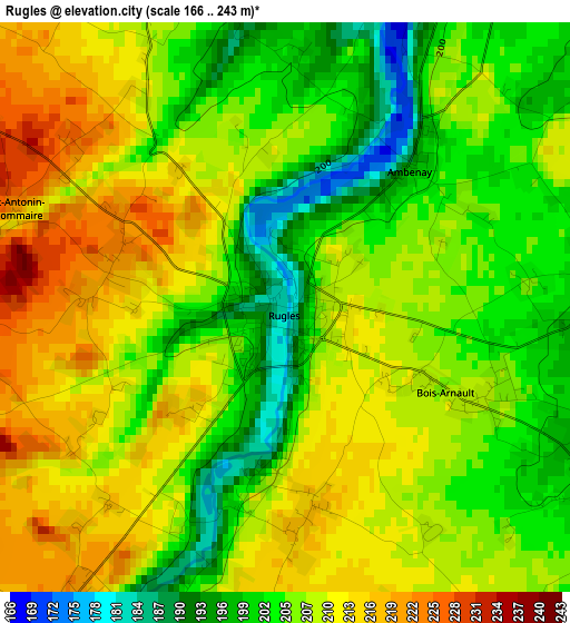
Below is the Elevation map of Rugles, which displays elevation range with different colors. Scale of the first map is from 166 to 243 m (545 to 797 ft) with average elevation of 207.3 meters (=680 ft) [note 1]
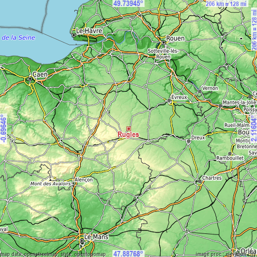
These maps also provides idea of topography and contour of this city, they are displayed at different zoom levels. More info about maps, scale and edge coordinates you can find below images.
| \ | Map #1 | Topo.Map |
| Scale [m] | 166..243 m | × |
| Scale [ft] | 545..797 ft | × |
| Average | 207.3 m = 680 ft | × |
| Width | 6.43 km = 4 mi | 205.9 km = 127.9 mi |
| Height | 6.43 km = 4 mi | 205.9 km = 127.9 mi |
| ↑Max Latitude | 48.851045° | 49.73945° |
| Latitude at center | 48.82212° | 48.82212° |
| ↓Min Latitude | 48.793178° | 47.88768° |
| ← Min Longitude | 0.665845° | -0.69646° |
| Longitude center | 0.70979° | 0.70979° |
| →Max Longitude | 0.753735° | 2.11604° |
Nearby cities:
Cities around Rugles sort by population:
• Verneuil-sur-Avre elevation 176 m
18.4 km,  119°
119°
• Conches-en-Ouche 152 m
22.6 km,  48°
48°
• Breteuil 168 m
15.2 km,  85°
85°
• Rai 210 m
12.3 km,  229°
229°
• Tourouvre 250 m
26.2 km,  189°
189°
• Aube-sur-Rîle 245 m
14.8 km, 231°
• Saint-Sulpice-sur-Risle 206 m
6 km,  219°
219°
• Sainte-Gauburge-Sainte-Colombe 237 m
23.5 km,  240°
240°
• Tillières-sur-Avre 135 m
26.3 km,  106°
106°
• Francheville 181 m
11 km, 111°
• Bourth 193 m
9.4 km,  129°
129°
• Broglie 148 m
24.6 km,  327°
327°
Multilingual:
 En español:
Rugles elevación 181 m.
 En France:
Rugles élévation 181 m.


Sources and notes:
- [note 1] Map square and city borders are not equal. Map elevation data is calculated only from area inside that square.
- [src 1] Elevation data from geonames database provided with same terms of usage.
- [src 2] The elevation map of Rugles is generated using elevation data from NASA's 3 arcsec (90m) resolution SRTM data.
- [src 3] Base (background) map © OpenStreetMap contributors tiles are generated by Geofabrik and OpenTopoMap.
Copyright & License:
This Rugles Elevation Map is licensed under CC BY-SA. You may reuse any part from this page, if you give a proper credit by linking to this URL:
 More info on terms of use page.