Sagy elevation
Sagy (Bourgogne-Franche-Comté, Département de Saône-et-Loire), France elevation is 202 meters and Sagy elevation in feet is 663 ft above sea level [src 1]. Sagy is a populated place (feature code) with elevation that is 28 meters (92 ft) bigger than average city elevation in France.
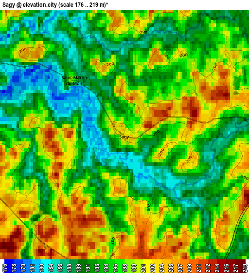
Below is the Elevation map of Sagy, which displays elevation range with different colors. Scale of the first map is from 176 to 219 m (577 to 719 ft) with average elevation of 196 meters (=643 ft) [note 1]
These maps also provides idea of topography and contour of this city, they are displayed at different zoom levels. More info about maps, scale and edge coordinates you can find below images.
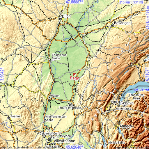
| \ | Map #1 | Topo.Map |
| Scale [m] | 176..219 m | × |
| Scale [ft] | 577..719 ft | × |
| Average | 196 m = 643 ft | × |
| Width | 6.71 km = 4.2 mi | 214.9 km = 133.5 mi |
| Height | 6.71 km = 4.2 mi | 214.8 km = 133.5 mi |
| ↑Max Latitude | 46.631475° | 47.55887° |
| Latitude at center | 46.60129° | 46.60129° |
| ↓Min Latitude | 46.571088° | 45.62648° |
| ← Min Longitude | 5.266505° | 3.9042° |
| Longitude center | 5.31045° | 5.31045° |
| →Max Longitude | 5.354395° | 6.7167° |
Nearby cities:
Cities around Sagy sort by population:
• Louhans elevation 180 m
7.1 km,  293°
293°
• Montmorot 236 m
18.2 km,  63°
63°
• Saint-Amour 256 m
18.5 km,  171°
171°
• Branges 191 m
10.7 km,  296°
296°
• Saint-Germain-du-Bois 211 m
17.6 km,  343°
343°
• Cuiseaux 283 m
13.3 km,  153°
153°
• Sornay 178 m
10.5 km, 287°
• Bletterans 201 m
19.5 km,  34°
34°
• Cousance 245 m
9.8 km,  140°
140°
• Saint-Usuge 200 m
9.8 km,  332°
332°
• Montpont-en-Bresse 203 m
12.2 km,  245°
245°
• Varennes-Saint-Sauveur 216 m
14.2 km,  201°
201°
Multilingual:
 En español:
Sagy elevación 202 m.
 En France:
Sagy élévation 202 m.


Sources and notes:
- [note 1] Map square and city borders are not equal. Map elevation data is calculated only from area inside that square.
- [src 1] Elevation data from geonames database provided with same terms of usage.
- [src 2] The elevation map of Sagy is generated using elevation data from NASA's 3 arcsec (90m) resolution SRTM data.
- [src 3] Base (background) map © OpenStreetMap contributors tiles are generated by Geofabrik and OpenTopoMap.
Copyright & License:
This Sagy Elevation Map is licensed under CC BY-SA. You may reuse any part from this page, if you give a proper credit by linking to this URL:
 More info on terms of use page.