Saint-Benoît elevation
Saint-Benoît (Nouvelle-Aquitaine, Vienne), France elevation is 101 meters and Saint-Benoît elevation in feet is 331 ft above sea level [src 1]. Saint-Benoît is a populated place (feature code) with elevation that is 73 meters (240 ft) smaller than average city elevation in France.
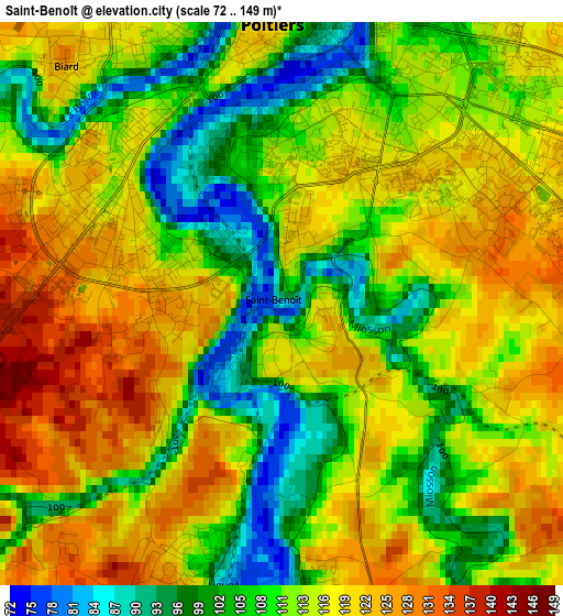
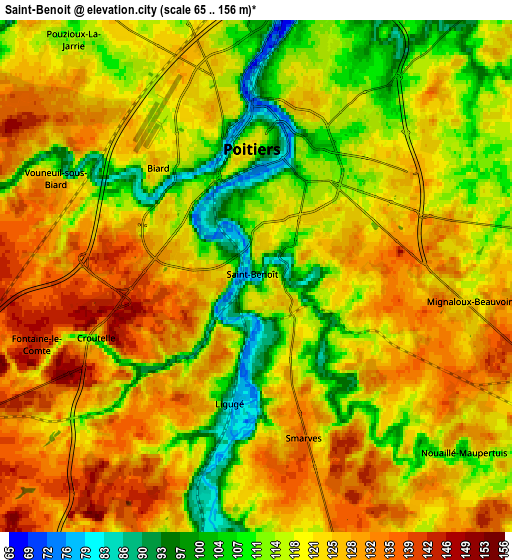
Below is the Elevation map of Saint-Benoît, which displays elevation range with different colors. Scale of the first map is from 72 to 149 m (236 to 489 ft) with average elevation of 113.3 meters (=372 ft) [note 1]
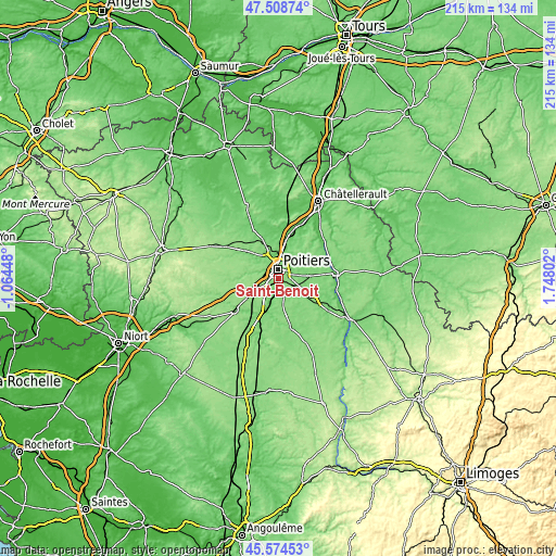
These maps also provides idea of topography and contour of this city, they are displayed at different zoom levels. More info about maps, scale and edge coordinates you can find below images.
| \ | Map #1 | Map #2 | Topo.Map |
| Scale [m] | 72..149 m | 65..156 m | × |
| Scale [ft] | 236..489 ft | 213..512 ft | × |
| Average | 113.3 m = 372 ft | 120.3 m = 395 ft | × |
| Width | 6.72 km = 4.2 mi | 13.44 km = 8.4 mi | 215.1 km = 133.7 mi |
| Height | 6.72 km = 4.2 mi | 13.44 km = 8.4 mi | 215.1 km = 133.7 mi |
| ↑Max Latitude | 46.580464° | 46.61066° | 47.50874° |
| Latitude at center | 46.55025° | 46.55025° | 46.55025° |
| ↓Min Latitude | 46.52002° | 46.489772° | 45.57453° |
| ← Min Longitude | 0.297825° | 0.253879° | -1.06448° |
| Longitude center | 0.34177° | 0.34177° | 0.34177° |
| →Max Longitude | 0.385715° | 0.429661° | 1.74802° |
Nearby cities:
Cities around Saint-Benoît sort by population:
• Poitiers elevation 85 m
3.6 km,  2°
2°
• Migné 100 m
8.8 km,  346°
346°
• Vouneuil-sous-Biard 122 m
6 km,  294°
294°
• Mignaloux-Beauvoir 121 m
5.6 km,  98°
98°
• Fontaine-le-Comte 143 m
6.4 km,  250°
250°
• Iteuil 117 m
7.3 km,  198°
198°
• Ligugé 124 m
3.6 km, 198°
• Nouaillé-Maupertuis 114 m
7.3 km,  130°
130°
• Smarves 123 m
4.4 km,  171°
171°
• Biard 120 m
4.1 km,  317°
317°
• Roches-Prémarie-Andillé 120 m
7.6 km,  163°
163°
• Roman catholic diocese of Poitiers 85 m
3.4 km,  9°
9°
Multilingual:
 En español:
Saint-Benoît elevación 101 m.
 En France:
Saint-Benoît élévation 101 m.
 Auf Deutsch:
Saint-Benoît höhe über dem Meeresspiegel ist 101 m.

Sources and notes:
- [note 1] Map square and city borders are not equal. Map elevation data is calculated only from area inside that square.
- [src 1] Elevation data from geonames database provided with same terms of usage.
- [src 2] The elevation map of Saint-Benoît is generated using elevation data from NASA's 3 arcsec (90m) resolution SRTM data.
- [src 3] Base (background) map © OpenStreetMap contributors tiles are generated by Geofabrik and OpenTopoMap.
Copyright & License:
This Saint-Benoît Elevation Map is licensed under CC BY-SA. You may reuse any part from this page, if you give a proper credit by linking to this URL:
 More info on terms of use page.