Saint-Gaudens elevation
Saint-Gaudens (Occitanie, Haute-Garonne), France elevation is 373 meters and Saint-Gaudens elevation in feet is 1224 ft above sea level [src 1]. Saint-Gaudens is a seat of a third-order administrative division (feature code) with elevation that is 199 meters (653 ft) bigger than average city elevation in France.
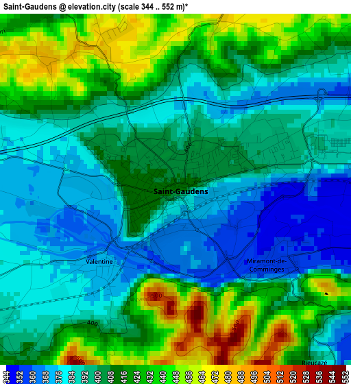
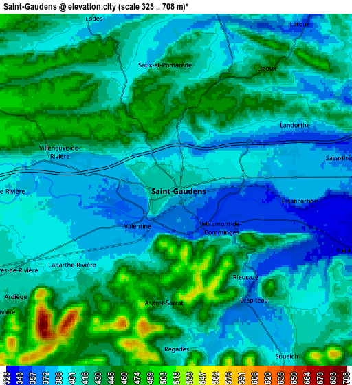
Below is the Elevation map of Saint-Gaudens, which displays elevation range with different colors. Scale of the first map is from 344 to 552 m (1129 to 1811 ft) with average elevation of 404.9 meters (=1328 ft) [note 1]
These maps also provides idea of topography and contour of this city, they are displayed at different zoom levels. More info about maps, scale and edge coordinates you can find below images.
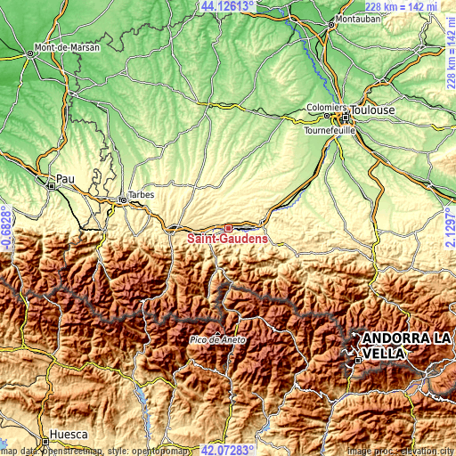
| \ | Map #1 | Map #2 | Topo.Map |
| Scale [m] | 344..552 m | 328..708 m | × |
| Scale [ft] | 1129..1811 ft | 1076..2323 ft | × |
| Average | 404.9 m = 1328 ft | 416.4 m = 1366 ft | × |
| Width | 7.13 km = 4.4 mi | 14.27 km = 8.9 mi | 228.3 km = 141.9 mi |
| Height | 7.13 km = 4.4 mi | 14.27 km = 8.9 mi | 228.3 km = 141.9 mi |
| ↑Max Latitude | 43.140165° | 43.172222° | 44.12613° |
| Latitude at center | 43.10809° | 43.10809° | 43.10809° |
| ↓Min Latitude | 43.075999° | 43.04389° | 42.07283° |
| ← Min Longitude | 0.679505° | 0.635559° | -0.6828° |
| Longitude center | 0.72345° | 0.72345° | 0.72345° |
| →Max Longitude | 0.767395° | 0.811341° | 2.1297° |
Nearby cities:
Cities around Saint-Gaudens sort by population:
• Lannemezan elevation 594 m
27.6 km,  273°
273°
• Cazères 246 m
31.4 km,  69°
69°
• Montréjeau 470 m
13.1 km,  258°
258°
• Salies-du-Salat 295 m
19.1 km,  92°
92°
• Martres-Tolosane 273 m
25.4 km, 66°
• Gourdan-Polignan 430 m
12.8 km,  251°
251°
• Boulogne-sur-Gesse 334 m
22.2 km,  344°
344°
• Villeneuve-de-Rivière 465 m
5.4 km,  294°
294°
• Labarthe-Rivière 394 m
5.2 km,  234°
234°
• Aurignac 392 m
17.6 km,  46°
46°
• La Barthe-de-Neste 580 m
27.7 km, 263°
• Aspet 479 m
12.2 km,  148°
148°
Multilingual:
 En español:
Saint-Gaudens elevación 373 m.
 En France:
Saint-Gaudens élévation 373 m.
 Auf Deutsch:
Saint-Gaudens höhe über dem Meeresspiegel ist 373 m.

Sources and notes:
- [note 1] Map square and city borders are not equal. Map elevation data is calculated only from area inside that square.
- [src 1] Elevation data from geonames database provided with same terms of usage.
- [src 2] The elevation map of Saint-Gaudens is generated using elevation data from NASA's 3 arcsec (90m) resolution SRTM data.
- [src 3] Base (background) map © OpenStreetMap contributors tiles are generated by Geofabrik and OpenTopoMap.
Copyright & License:
This Saint-Gaudens Elevation Map is licensed under CC BY-SA. You may reuse any part from this page, if you give a proper credit by linking to this URL:
 More info on terms of use page.