Saint-Genest-Lerpt elevation
Saint-Genest-Lerpt (Auvergne-Rhône-Alpes, Département de la Loire), France elevation is 498 meters and Saint-Genest-Lerpt elevation in feet is 1634 ft above sea level [src 1]. Saint-Genest-Lerpt is a populated place (feature code) with elevation that is 324 meters (1063 ft) bigger than average city elevation in France.
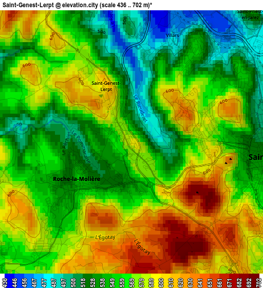
Below is the Elevation map of Saint-Genest-Lerpt, which displays elevation range with different colors. Scale of the first map is from 436 to 702 m (1430 to 2303 ft) with average elevation of 565.9 meters (=1857 ft) [note 1]
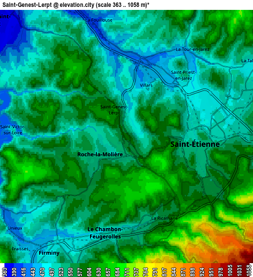
These maps also provides idea of topography and contour of this city, they are displayed at different zoom levels. More info about maps, scale and edge coordinates you can find below images.
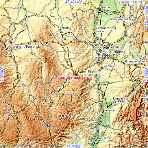
| \ | Map #1 | Map #2 | Topo.Map |
| Scale [m] | 436..702 m | 363..1058 m | × |
| Scale [ft] | 1430..2303 ft | 1191..3471 ft | × |
| Average | 565.9 m = 1857 ft | 560.5 m = 1839 ft | × |
| Width | 6.86 km = 4.3 mi | 13.71 km = 8.5 mi | 219.4 km = 136.3 mi |
| Height | 6.86 km = 4.3 mi | 13.71 km = 8.5 mi | 219.4 km = 136.3 mi |
| ↑Max Latitude | 45.474294° | 45.505101° | 46.42149° |
| Latitude at center | 45.44347° | 45.44347° | 45.44347° |
| ↓Min Latitude | 45.412629° | 45.381771° | 44.4482° |
| ← Min Longitude | 4.295735° | 4.251789° | 2.93343° |
| Longitude center | 4.33968° | 4.33968° | 4.33968° |
| →Max Longitude | 4.383625° | 4.427571° | 5.74593° |
Nearby cities:
Cities around Saint-Genest-Lerpt sort by population:
• Saint-Étienne elevation 529 m
4.1 km,  105°
105°
• Firminy 507 m
7.2 km,  213°
213°
• Le Chambon-Feugerolles 587 m
6 km,  193°
193°
• Roche-la-Molière 561 m
1.7 km, 212°
• Villars 468 m
3 km,  24°
24°
• Unieux 504 m
6.9 km,  230°
230°
• La Ricamarie 648 m
4.8 km,  151°
151°
• La Talaudière 502 m
7.6 km,  61°
61°
• Saint-Priest-en-Jarez 478 m
4.5 km,  40°
40°
• La Fouillouse 458 m
7.1 km,  344°
344°
• L’Étrat 548 m
5.5 km,  30°
30°
• La Tour-en-Jarez 575 m
6 km, 41°
Multilingual:
 En español:
Saint-Genest-Lerpt elevación 498 m.
 En France:
Saint-Genest-Lerpt élévation 498 m.
 Auf Deutsch:
Saint-Genest-Lerpt höhe über dem Meeresspiegel ist 498 m.
 На русском:
Saint-Genest-Lerpt высота над уровнем моря 498 м
Sources and notes:
- [note 1] Map square and city borders are not equal. Map elevation data is calculated only from area inside that square.
- [src 1] Elevation data from geonames database provided with same terms of usage.
- [src 2] The elevation map of Saint-Genest-Lerpt is generated using elevation data from NASA's 3 arcsec (90m) resolution SRTM data.
- [src 3] Base (background) map © OpenStreetMap contributors tiles are generated by Geofabrik and OpenTopoMap.
Copyright & License:
This Saint-Genest-Lerpt Elevation Map is licensed under CC BY-SA. You may reuse any part from this page, if you give a proper credit by linking to this URL:
 More info on terms of use page.