Saint-Girons elevation
Saint-Girons (Occitanie, Département de l'Ariège), France elevation is 449 meters and Saint-Girons elevation in feet is 1473 ft above sea level [src 1]. Saint-Girons is a seat of a third-order administrative division (feature code) with elevation that is 275 meters (902 ft) bigger than average city elevation in France.
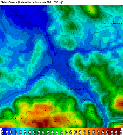
Below is the Elevation map of Saint-Girons, which displays elevation range with different colors. Scale of the first map is from 366 to 896 m (1201 to 2940 ft) with average elevation of 489.9 meters (=1607 ft) [note 1]
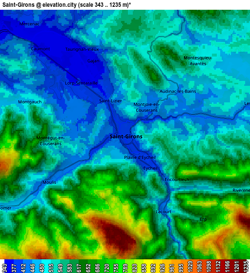
These maps also provides idea of topography and contour of this city, they are displayed at different zoom levels. More info about maps, scale and edge coordinates you can find below images.
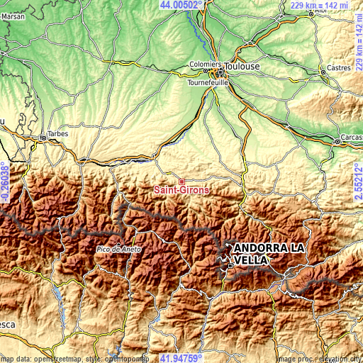
| \ | Map #1 | Map #2 | Topo.Map |
| Scale [m] | 366..896 m | 343..1235 m | × |
| Scale [ft] | 1201..2940 ft | 1125..4052 ft | × |
| Average | 489.9 m = 1607 ft | 568.4 m = 1865 ft | × |
| Width | 7.15 km = 4.4 mi | 14.3 km = 8.9 mi | 228.8 km = 142.2 mi |
| Height | 7.15 km = 4.4 mi | 14.3 km = 8.9 mi | 228.8 km = 142.2 mi |
| ↑Max Latitude | 43.017049° | 43.049171° | 44.00502° |
| Latitude at center | 42.98491° | 42.98491° | 42.98491° |
| ↓Min Latitude | 42.952754° | 42.920581° | 41.94759° |
| ← Min Longitude | 1.101925° | 1.057979° | -0.26038° |
| Longitude center | 1.14587° | 1.14587° | 1.14587° |
| →Max Longitude | 1.189815° | 1.233761° | 2.55212° |
Nearby cities:
Cities around Saint-Girons sort by population:
• Carbonne elevation 211 m
35.5 km,  10°
10°
• Cazères 246 m
25.2 km,  348°
348°
• Montesquieu-Volvestre 231 m
25.6 km,  15°
15°
• Salies-du-Salat 295 m
19.9 km,  310°
310°
• Lézat-sur-Lèze 221 m
36.4 km,  26°
26°
• Rieux-Volvestre 218 m
29.8 km, 8°
• Martres-Tolosane 273 m
26.2 km,  335°
335°
• Saint-Lizier 427 m
2 km, 338°
• Le Fousseret 306 m
33.7 km, 348°
• Aurignac 392 m
33.5 km,  320°
320°
• Aspet 479 m
28.1 km,  276°
276°
• Montjoie-en-Couserans 451 m
2.3 km, 30°
Multilingual:
 En español:
Saint-Girons elevación 449 m.
 En France:
Saint-Girons élévation 449 m.
 Auf Deutsch:
Saint-Girons höhe über dem Meeresspiegel ist 449 m.

Sources and notes:
- [note 1] Map square and city borders are not equal. Map elevation data is calculated only from area inside that square.
- [src 1] Elevation data from geonames database provided with same terms of usage.
- [src 2] The elevation map of Saint-Girons is generated using elevation data from NASA's 3 arcsec (90m) resolution SRTM data.
- [src 3] Base (background) map © OpenStreetMap contributors tiles are generated by Geofabrik and OpenTopoMap.
Copyright & License:
This Saint-Girons Elevation Map is licensed under CC BY-SA. You may reuse any part from this page, if you give a proper credit by linking to this URL:
 More info on terms of use page.