Saint-Jean-de-Sixt elevation
Saint-Jean-de-Sixt (Auvergne-Rhône-Alpes, Haute-Savoie), France elevation is 1080 meters and Saint-Jean-de-Sixt elevation in feet is 3543 ft above sea level [src 1]. Saint-Jean-de-Sixt is a populated place (feature code) with elevation that is 906 meters (2972 ft) bigger than average city elevation in France.
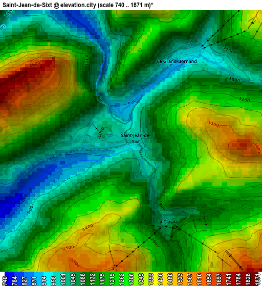
Below is the Elevation map of Saint-Jean-de-Sixt, which displays elevation range with different colors. Scale of the first map is from 740 to 1871 m (2428 to 6138 ft) with average elevation of 1199.5 meters (=3935 ft) [note 1]
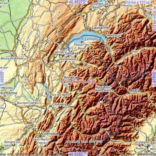
These maps also provides idea of topography and contour of this city, they are displayed at different zoom levels. More info about maps, scale and edge coordinates you can find below images.
| \ | Map #1 | Topo.Map |
| Scale [m] | 740..1871 m | × |
| Scale [ft] | 2428..6138 ft | × |
| Average | 1199.5 m = 3935 ft | × |
| Width | 6.8 km = 4.2 mi | 217.5 km = 135.1 mi |
| Height | 6.8 km = 4.2 mi | 217.5 km = 135.1 mi |
| ↑Max Latitude | 45.953681° | 46.89272° |
| Latitude at center | 45.92312° | 45.92312° |
| ↓Min Latitude | 45.892542° | 44.93627° |
| ← Min Longitude | 6.367855° | 5.00555° |
| Longitude center | 6.4118° | 6.4118° |
| →Max Longitude | 6.455745° | 7.81805° |
Nearby cities:
Cities around Saint-Jean-de-Sixt sort by population:
• Sallanches elevation 542 m
17.2 km,  82°
82°
• Bonneville 450 m
17.5 km,  358°
358°
• Thônes 627 m
8.1 km,  235°
235°
• Thorens-Glières 659 m
15.1 km,  301°
301°
• Le Grand-Bornand 983 m
2.6 km,  34°
34°
• Villaz 745 m
17.1 km,  280°
280°
• La Clusaz 1203 m
2.5 km,  136°
136°
• Mont-Saxonnex 954 m
15 km,  18°
18°
• Praz-sur-Arly 1012 m
15.7 km,  127°
127°
• Vougy 458 m
16.7 km, 16°
• Dingy-Saint-Clair 658 m
14.5 km,  262°
262°
• Cordon 872 m
15 km,  90°
90°
Multilingual:
 En español:
Saint-Jean-de-Sixt elevación 1080 m.
 En France:
Saint-Jean-de-Sixt élévation 1080 m.
 Auf Deutsch:
Saint-Jean-de-Sixt höhe über dem Meeresspiegel ist 1080 m.
 На русском:
Saint-Jean-de-Sixt высота над уровнем моря 1080 м
Sources and notes:
- [note 1] Map square and city borders are not equal. Map elevation data is calculated only from area inside that square.
- [src 1] Elevation data from geonames database provided with same terms of usage.
- [src 2] The elevation map of Saint-Jean-de-Sixt is generated using elevation data from NASA's 3 arcsec (90m) resolution SRTM data.
- [src 3] Base (background) map © OpenStreetMap contributors tiles are generated by Geofabrik and OpenTopoMap.
Copyright & License:
This Saint-Jean-de-Sixt Elevation Map is licensed under CC BY-SA. You may reuse any part from this page, if you give a proper credit by linking to this URL:
 More info on terms of use page.