Saint-Léon-sur-l’Isle elevation
Saint-Léon-sur-l’Isle (Nouvelle-Aquitaine, Dordogne), France elevation is 67 meters and Saint-Léon-sur-l’Isle elevation in feet is 220 ft above sea level [src 1]. Saint-Léon-sur-l’Isle is a populated place (feature code) with elevation that is 107 meters (351 ft) smaller than average city elevation in France.
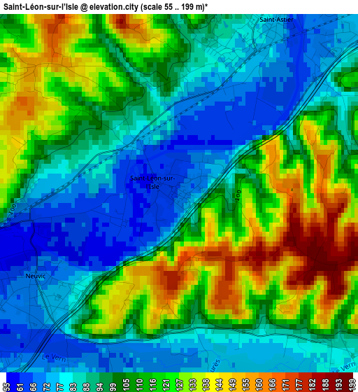
Below is the Elevation map of Saint-Léon-sur-l’Isle, which displays elevation range with different colors. Scale of the first map is from 55 to 199 m (180 to 653 ft) with average elevation of 103 meters (=338 ft) [note 1]
These maps also provides idea of topography and contour of this city, they are displayed at different zoom levels. More info about maps, scale and edge coordinates you can find below images.
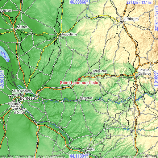
| \ | Map #1 | Topo.Map |
| Scale [m] | 55..199 m | × |
| Scale [ft] | 180..653 ft | × |
| Average | 103 m = 338 ft | × |
| Width | 6.9 km = 4.3 mi | 220.7 km = 137.1 mi |
| Height | 6.9 km = 4.3 mi | 220.7 km = 137.1 mi |
| ↑Max Latitude | 45.145913° | 46.09866° |
| Latitude at center | 45.11491° | 45.11491° |
| ↓Min Latitude | 45.08389° | 44.11391° |
| ← Min Longitude | 0.460495° | -0.90181° |
| Longitude center | 0.50444° | 0.50444° |
| →Max Longitude | 0.548385° | 1.91069° |
Nearby cities:
Cities around Saint-Léon-sur-l’Isle sort by population:
• Coulounieix-Chamiers elevation 179 m
15 km,  73°
73°
• Saint-Astier 80 m
3.9 km,  29°
29°
• Neuvic 71 m
3.2 km,  239°
239°
• Mussidan 60 m
14.2 km,  231°
231°
• Razac-sur-l’Isle 90 m
9.3 km,  54°
54°
• Saint-Médard-de-Mussidan 58 m
15.1 km, 233°
• Tocane-Saint-Apre 81 m
15.5 km,  357°
357°
• Coursac 156 m
10.7 km,  81°
81°
• Annesse-et-Beaulieu 73 m
7.6 km,  44°
44°
• Mensignac 202 m
13.1 km,  20°
20°
• Montrem 156 m
7.1 km, 72°
• Sourzac 87 m
11.2 km, 229°
Multilingual:
 En español:
Saint-Léon-sur-l’Isle elevación 67 m.
 En France:
Saint-Léon-sur-l’Isle élévation 67 m.
 Auf Deutsch:
Saint-Léon-sur-l’Isle höhe über dem Meeresspiegel ist 67 m.
 На русском:
Saint-Léon-sur-l’Isle высота над уровнем моря 67 м
Sources and notes:
- [note 1] Map square and city borders are not equal. Map elevation data is calculated only from area inside that square.
- [src 1] Elevation data from geonames database provided with same terms of usage.
- [src 2] The elevation map of Saint-Léon-sur-l’Isle is generated using elevation data from NASA's 3 arcsec (90m) resolution SRTM data.
- [src 3] Base (background) map © OpenStreetMap contributors tiles are generated by Geofabrik and OpenTopoMap.
Copyright & License:
This Saint-Léon-sur-l’Isle Elevation Map is licensed under CC BY-SA. You may reuse any part from this page, if you give a proper credit by linking to this URL:
 More info on terms of use page.