Saint-Saturnin-lès-Avignon elevation
Saint-Saturnin-lès-Avignon (Provence-Alpes-Côte d'Azur, Département du Vaucluse), France elevation is 66 meters and Saint-Saturnin-lès-Avignon elevation in feet is 217 ft above sea level [src 1]. Saint-Saturnin-lès-Avignon is a populated place (feature code) with elevation that is 108 meters (354 ft) smaller than average city elevation in France.
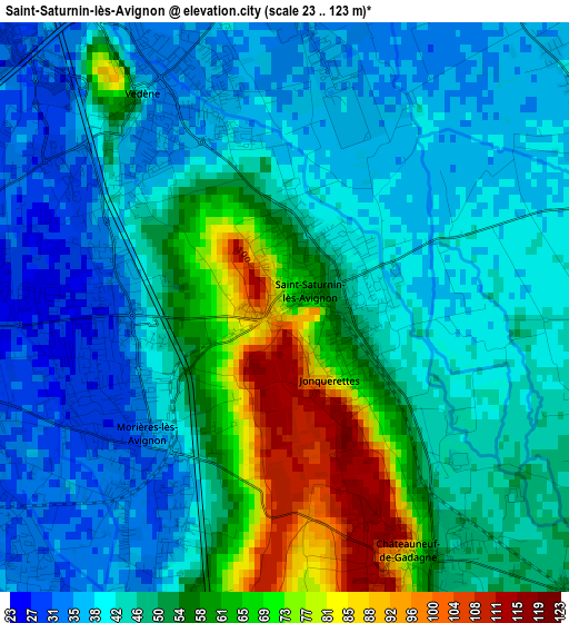
Below is the Elevation map of Saint-Saturnin-lès-Avignon, which displays elevation range with different colors. Scale of the first map is from 23 to 123 m (75 to 404 ft) with average elevation of 48.5 meters (=159 ft) [note 1]
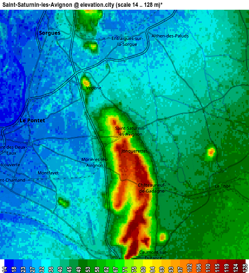
These maps also provides idea of topography and contour of this city, they are displayed at different zoom levels. More info about maps, scale and edge coordinates you can find below images.
| \ | Map #1 | Map #2 | Topo.Map |
| Scale [m] | 23..123 m | 14..128 m | × |
| Scale [ft] | 75..404 ft | 46..420 ft | × |
| Average | 48.5 m = 159 ft | 41.7 m = 137 ft | × |
| Width | 7.04 km = 4.4 mi | 14.07 km = 8.7 mi | 225.1 km = 139.9 mi |
| Height | 7.04 km = 4.4 mi | 14.07 km = 8.7 mi | 225.1 km = 139.9 mi |
| ↑Max Latitude | 43.986637° | 44.018247° | 44.95872° |
| Latitude at center | 43.95501° | 43.95501° | 43.95501° |
| ↓Min Latitude | 43.923366° | 43.891705° | 42.93405° |
| ← Min Longitude | 4.881535° | 4.837589° | 3.51923° |
| Longitude center | 4.92548° | 4.92548° | 4.92548° |
| →Max Longitude | 4.969425° | 5.013371° | 6.33173° |
Nearby cities:
Cities around Saint-Saturnin-lès-Avignon sort by population:
• Sorgues elevation 30 m
7.4 km,  326°
326°
• Le Pontet 25 m
5.3 km,  277°
277°
• Montfavet 34 m
4.8 km,  239°
239°
• Vedène 36 m
3 km, 325°
• Entraigues-sur-la-Sorgue 27 m
5.4 km,  0°
0°
• Le Thor 53 m
6.3 km,  116°
116°
• Morières-lès-Avignon 29 m
2.5 km,  230°
230°
• Caumont-sur-Durance 50 m
7.1 km,  165°
165°
• Châteauneuf-de-Gadagne 76 m
3.5 km,  154°
154°
• Velleron 65 m
8.3 km,  88°
88°
• Althen-des-Paluds 33 m
6.1 km,  25°
25°
• Jonquerettes 82 m
1.1 km, 147°
Multilingual:
 En español:
Saint-Saturnin-lès-Avignon elevación 66 m.
 En France:
Saint-Saturnin-lès-Avignon élévation 66 m.
 Auf Deutsch:
Saint-Saturnin-lès-Avignon höhe über dem Meeresspiegel ist 66 m.
 На русском:
Сен-Сатюрнен-лез-Авиньон высота над уровнем моря 66 м
Sources and notes:
- [note 1] Map square and city borders are not equal. Map elevation data is calculated only from area inside that square.
- [src 1] Elevation data from geonames database provided with same terms of usage.
- [src 2] The elevation map of Saint-Saturnin-lès-Avignon is generated using elevation data from NASA's 3 arcsec (90m) resolution SRTM data.
- [src 3] Base (background) map © OpenStreetMap contributors tiles are generated by Geofabrik and OpenTopoMap.
Copyright & License:
This Saint-Saturnin-lès-Avignon Elevation Map is licensed under CC BY-SA. You may reuse any part from this page, if you give a proper credit by linking to this URL:
 More info on terms of use page.