Saint-Victoret elevation
Saint-Victoret (Provence-Alpes-Côte d'Azur, Département des Bouches-du-Rhône), France elevation is 24 meters and Saint-Victoret elevation in feet is 79 ft above sea level [src 1]. Saint-Victoret is a populated place (feature code) with elevation that is 150 meters (492 ft) smaller than average city elevation in France.
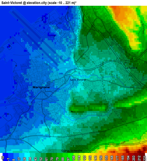
Below is the Elevation map of Saint-Victoret, which displays elevation range with different colors. Scale of the first map is from -10 to 221 m (-33 to 725 ft) with average elevation of 41.6 meters (=136 ft) [note 1]
These maps also provides idea of topography and contour of this city, they are displayed at different zoom levels. More info about maps, scale and edge coordinates you can find below images.
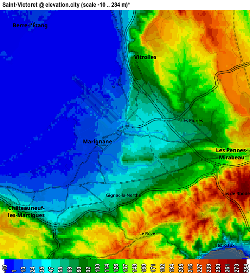
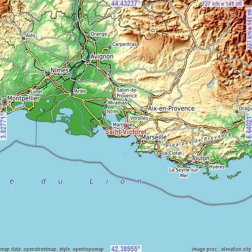
| \ | Map #1 | Map #2 | Topo.Map |
| Scale [m] | -10..221 m | -10..284 m | × |
| Scale [ft] | -33..725 ft | -33..932 ft | × |
| Average | 41.6 m = 136 ft | 86.3 m = 283 ft | × |
| Width | 7.1 km = 4.4 mi | 14.2 km = 8.8 mi | 227.1 km = 141.1 mi |
| Height | 7.1 km = 4.4 mi | 14.2 km = 8.8 mi | 227.1 km = 141.1 mi |
| ↑Max Latitude | 43.451481° | 43.483375° | 44.43237° |
| Latitude at center | 43.41957° | 43.41957° | 43.41957° |
| ↓Min Latitude | 43.387642° | 43.355698° | 42.38955° |
| ← Min Longitude | 5.190015° | 5.146069° | 3.82771° |
| Longitude center | 5.23396° | 5.23396° | 5.23396° |
| →Max Longitude | 5.277905° | 5.321851° | 6.64021° |
Nearby cities:
Cities around Saint-Victoret sort by population:
• Vitrolles elevation 136 m
4.6 km,  14°
14°
• Marignane 14 m
1.6 km,  260°
260°
• Les Pennes-Mirabeau 159 m
6.1 km,  99°
99°
• Berre-l'Étang 3 m
8.3 km,  321°
321°
• Rognac 37 m
7.6 km,  359°
359°
• Châteauneuf-les-Martigues 19 m
6.9 km,  234°
234°
• Gignac-la-Nerthe 60 m
3 km,  177°
177°
• Verduron 158 m
10.5 km,  121°
121°
• L'Estaque 40 m
8.6 km,  135°
135°
• Saint-Henri 49 m
10.1 km,  129°
129°
• Ensuès-la-Redonne 101 m
7.6 km,  198°
198°
• Le Rove 156 m
5.7 km,  165°
165°
Multilingual:
 En español:
Saint-Victoret elevación 24 m.
 En France:
Saint-Victoret élévation 24 m.
 Auf Deutsch:
Saint-Victoret höhe über dem Meeresspiegel ist 24 m.

Sources and notes:
- [note 1] Map square and city borders are not equal. Map elevation data is calculated only from area inside that square.
- [src 1] Elevation data from geonames database provided with same terms of usage.
- [src 2] The elevation map of Saint-Victoret is generated using elevation data from NASA's 3 arcsec (90m) resolution SRTM data.
- [src 3] Base (background) map © OpenStreetMap contributors tiles are generated by Geofabrik and OpenTopoMap.
Copyright & License:
This Saint-Victoret Elevation Map is licensed under CC BY-SA. You may reuse any part from this page, if you give a proper credit by linking to this URL:
 More info on terms of use page.