Sarbazan elevation
Sarbazan (Nouvelle-Aquitaine, Landes), France elevation is 96 meters and Sarbazan elevation in feet is 315 ft above sea level [src 1]. Sarbazan is a populated place (feature code) with elevation that is 78 meters (256 ft) smaller than average city elevation in France.
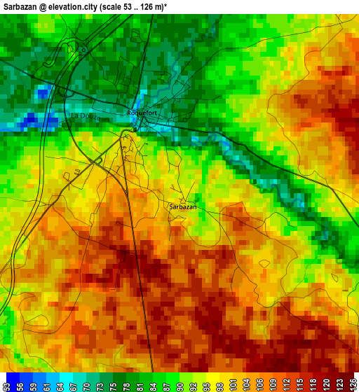
Below is the Elevation map of Sarbazan, which displays elevation range with different colors. Scale of the first map is from 53 to 126 m (174 to 413 ft) with average elevation of 96.7 meters (=317 ft) [note 1]
These maps also provides idea of topography and contour of this city, they are displayed at different zoom levels. More info about maps, scale and edge coordinates you can find below images.
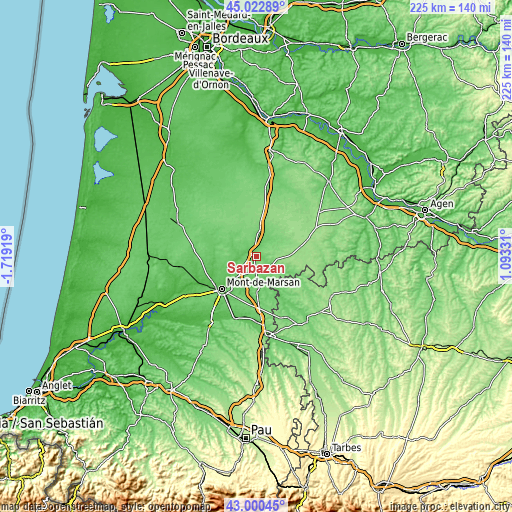
| \ | Map #1 | Topo.Map |
| Scale [m] | 53..126 m | × |
| Scale [ft] | 174..413 ft | × |
| Average | 96.7 m = 317 ft | × |
| Width | 7.03 km = 4.4 mi | 224.9 km = 139.7 mi |
| Height | 7.03 km = 4.4 mi | 224.9 km = 139.7 mi |
| ↑Max Latitude | 44.051882° | 45.02289° |
| Latitude at center | 44.02029° | 44.02029° |
| ↓Min Latitude | 43.988681° | 43.00045° |
| ← Min Longitude | -0.356885° | -1.71919° |
| Longitude center | -0.31294° | -0.31294° |
| →Max Longitude | -0.268995° | 1.09331° |
Nearby cities:
Cities around Sarbazan sort by population:
• Mont-de-Marsan elevation 51 m
20.7 km,  225°
225°
• Saint-Pierre-du-Mont 79 m
22.5 km, 227°
• Grenade-sur-l’Adour 55 m
28.6 km,  199°
199°
• Villeneuve-de-Marsan 90 m
14.6 km,  178°
178°
• Roquefort 63 m
1.8 km,  333°
333°
• Cazaubon 143 m
21.8 km,  116°
116°
• Gabarret 153 m
26.1 km,  97°
97°
• Captieux 97 m
30.5 km,  7°
7°
• Benquet 71 m
26 km,  215°
215°
• Le Houga 149 m
29.4 km,  158°
158°
• Cazères-sur-l’Adour 75 m
28.8 km, 180°
• Saint-Perdon 81 m
28.1 km, 232°
Multilingual:
 En español:
Sarbazan elevación 96 m.
 En France:
Sarbazan élévation 96 m.


Sources and notes:
- [note 1] Map square and city borders are not equal. Map elevation data is calculated only from area inside that square.
- [src 1] Elevation data from geonames database provided with same terms of usage.
- [src 2] The elevation map of Sarbazan is generated using elevation data from NASA's 3 arcsec (90m) resolution SRTM data.
- [src 3] Base (background) map © OpenStreetMap contributors tiles are generated by Geofabrik and OpenTopoMap.
Copyright & License:
This Sarbazan Elevation Map is licensed under CC BY-SA. You may reuse any part from this page, if you give a proper credit by linking to this URL:
 More info on terms of use page.