Solignac elevation
Solignac (Nouvelle-Aquitaine, Haute-Vienne), France elevation is 241 meters and Solignac elevation in feet is 791 ft above sea level [src 1]. Solignac is a populated place (feature code) with elevation that is 67 meters (220 ft) bigger than average city elevation in France.
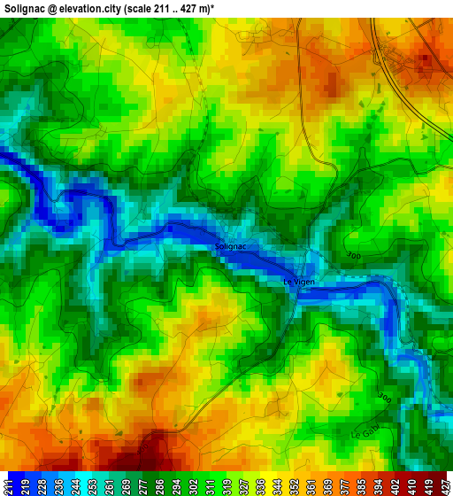
Below is the Elevation map of Solignac, which displays elevation range with different colors. Scale of the first map is from 211 to 427 m (692 to 1401 ft) with average elevation of 312.4 meters (=1025 ft) [note 1]
These maps also provides idea of topography and contour of this city, they are displayed at different zoom levels. More info about maps, scale and edge coordinates you can find below images.
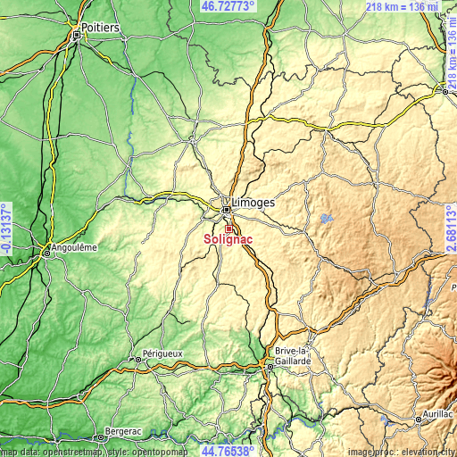
| \ | Map #1 | Topo.Map |
| Scale [m] | 211..427 m | × |
| Scale [ft] | 692..1401 ft | × |
| Average | 312.4 m = 1025 ft | × |
| Width | 6.82 km = 4.2 mi | 218.2 km = 135.6 mi |
| Height | 6.82 km = 4.2 mi | 218.2 km = 135.6 mi |
| ↑Max Latitude | 45.785833° | 46.72773° |
| Latitude at center | 45.75518° | 45.75518° |
| ↓Min Latitude | 45.72451° | 44.76538° |
| ← Min Longitude | 1.230935° | -0.13137° |
| Longitude center | 1.27488° | 1.27488° |
| →Max Longitude | 1.318825° | 2.68113° |
Nearby cities:
Cities around Solignac sort by population:
• Limoges elevation 289 m
9 km,  346°
346°
• Panazol 308 m
9.7 km,  16°
16°
• Isle 246 m
6.7 km,  325°
325°
• Aixe-sur-Vienne 222 m
11.7 km,  293°
293°
• Feytiat 341 m
7.5 km,  35°
35°
• Condat-sur-Vienne 266 m
5.4 km,  321°
321°
• Nexon 351 m
10.9 km,  219°
219°
• Bosmie-l'Aiguille 250 m
5.8 km,  264°
264°
• Boisseuil 370 m
4.7 km,  69°
69°
• Le Vigen 242 m
1.1 km,  109°
109°
• Saint-Paul 318 m
12.2 km,  92°
92°
• Pierre-Buffière 299 m
9.4 km,  135°
135°
Multilingual:
 En español:
Solignac elevación 241 m.
 En France:
Solignac élévation 241 m.
 Auf Deutsch:
Solignac höhe über dem Meeresspiegel ist 241 m.

Sources and notes:
- [note 1] Map square and city borders are not equal. Map elevation data is calculated only from area inside that square.
- [src 1] Elevation data from geonames database provided with same terms of usage.
- [src 2] The elevation map of Solignac is generated using elevation data from NASA's 3 arcsec (90m) resolution SRTM data.
- [src 3] Base (background) map © OpenStreetMap contributors tiles are generated by Geofabrik and OpenTopoMap.
Copyright & License:
This Solignac Elevation Map is licensed under CC BY-SA. You may reuse any part from this page, if you give a proper credit by linking to this URL:
 More info on terms of use page.