Stenay elevation
Stenay (Grand Est, Meuse), France elevation is 169 meters and Stenay elevation in feet is 554 ft above sea level [src 1]. Stenay is a populated place (feature code) with elevation that is 5 meters (16 ft) smaller than average city elevation in France.
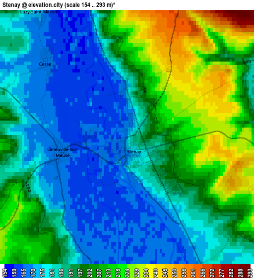
Below is the Elevation map of Stenay, which displays elevation range with different colors. Scale of the first map is from 154 to 293 m (505 to 961 ft) with average elevation of 193.7 meters (=635 ft) [note 1]
These maps also provides idea of topography and contour of this city, they are displayed at different zoom levels. More info about maps, scale and edge coordinates you can find below images.
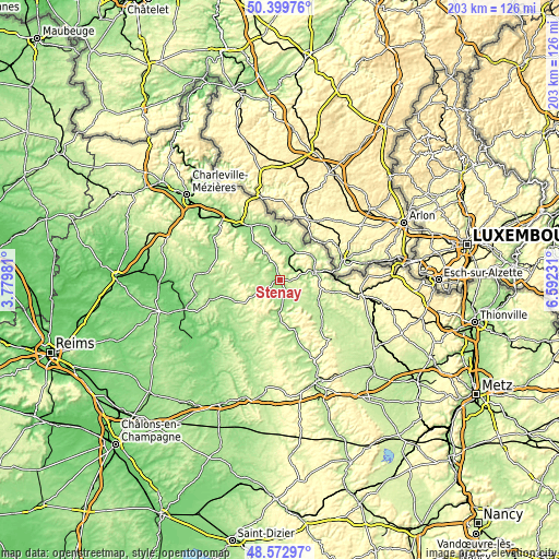
| \ | Map #1 | Topo.Map |
| Scale [m] | 154..293 m | × |
| Scale [ft] | 505..961 ft | × |
| Average | 193.7 m = 635 ft | × |
| Width | 6.35 km = 3.9 mi | 203.1 km = 126.2 mi |
| Height | 6.35 km = 3.9 mi | 203.1 km = 126.2 mi |
| ↑Max Latitude | 49.523425° | 50.39976° |
| Latitude at center | 49.49489° | 49.49489° |
| ↓Min Latitude | 49.466338° | 48.57297° |
| ← Min Longitude | 5.142115° | 3.77981° |
| Longitude center | 5.18606° | 5.18606° |
| →Max Longitude | 5.230005° | 6.59231° |
Nearby cities:
Cities around Stenay sort by population:
• Sedan elevation 166 m
29 km,  322°
322°
• Longuyon 298 m
30.8 km,  101°
101°
• Carignan 174 m
15.3 km,  355°
355°
• Mouzon 158 m
14.8 km,  327°
327°
• Floing 159 m
31.3 km, 323°
• Donchery 151 m
31.7 km,  314°
314°
• Montmédy 195 m
13.5 km,  77°
77°
• Bazeilles 165 m
25.2 km, 323°
• Balan 165 m
26.8 km, 323°
• Douzy 163 m
22.2 km, 331°
• Blagny 169 m
14.1 km,  1°
1°
• Pouru-Saint-Remy 177 m
22.2 km,  340°
340°
Multilingual:
 En español:
Stenay elevación 169 m.
 En France:
Stenay élévation 169 m.


Sources and notes:
- [note 1] Map square and city borders are not equal. Map elevation data is calculated only from area inside that square.
- [src 1] Elevation data from geonames database provided with same terms of usage.
- [src 2] The elevation map of Stenay is generated using elevation data from NASA's 3 arcsec (90m) resolution SRTM data.
- [src 3] Base (background) map © OpenStreetMap contributors tiles are generated by Geofabrik and OpenTopoMap.
Copyright & License:
This Stenay Elevation Map is licensed under CC BY-SA. You may reuse any part from this page, if you give a proper credit by linking to this URL:
 More info on terms of use page.