Suèvres elevation
Suèvres (Centre, Département du Loir-et-Cher), France elevation is 82 meters and Suèvres elevation in feet is 269 ft above sea level [src 1]. Suèvres is a populated place (feature code) with elevation that is 92 meters (302 ft) smaller than average city elevation in France.
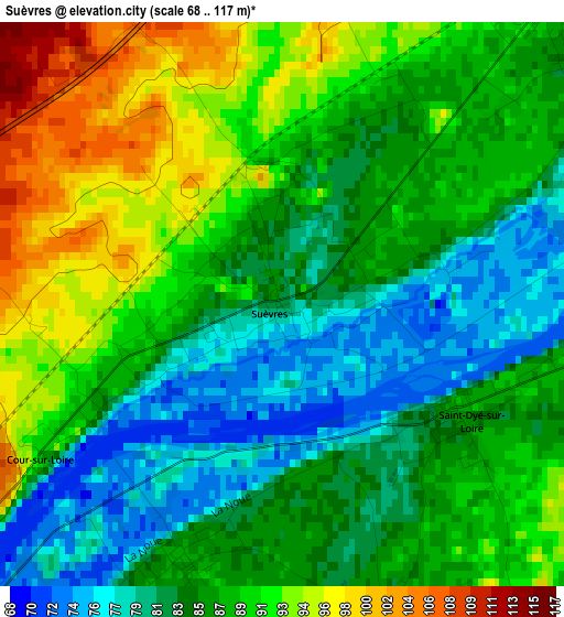
Below is the Elevation map of Suèvres, which displays elevation range with different colors. Scale of the first map is from 68 to 117 m (223 to 384 ft) with average elevation of 86.8 meters (=285 ft) [note 1]
These maps also provides idea of topography and contour of this city, they are displayed at different zoom levels. More info about maps, scale and edge coordinates you can find below images.
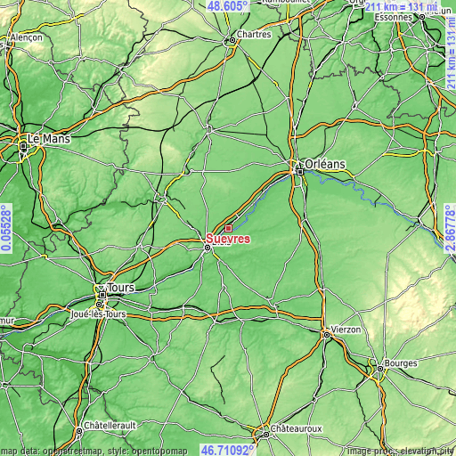
| \ | Map #1 | Topo.Map |
| Scale [m] | 68..117 m | × |
| Scale [ft] | 223..384 ft | × |
| Average | 86.8 m = 285 ft | × |
| Width | 6.58 km = 4.1 mi | 210.6 km = 130.9 mi |
| Height | 6.58 km = 4.1 mi | 210.6 km = 130.9 mi |
| ↑Max Latitude | 47.696136° | 48.605° |
| Latitude at center | 47.66655° | 47.66655° |
| ↓Min Latitude | 47.636947° | 46.71092° |
| ← Min Longitude | 1.417585° | 0.05528° |
| Longitude center | 1.46153° | 1.46153° |
| →Max Longitude | 1.505475° | 2.86778° |
Nearby cities:
Cities around Suèvres sort by population:
• Blois elevation 108 m
12.8 km,  231°
231°
• Vineuil 84 m
11.2 km,  214°
214°
• Mer 95 m
5.5 km,  37°
37°
• La Chaussée-Saint-Victor 99 m
9 km, 231°
• Saint-Laurent-Nouan 78 m
11.8 km,  61°
61°
• Mont-près-Chambord 105 m
11.6 km,  181°
181°
• Villebarou 116 m
11.5 km,  245°
245°
• Huisseau-sur-Cosson 78 m
8.2 km, 184°
• Saint-Claude-de-Diray 84 m
6.4 km, 210°
• Montlivault 87 m
3.2 km,  202°
202°
• Muides-sur-Loire 81 m
4.9 km,  86°
86°
• Saint-Dyé-sur-Loire 89 m
2.3 km,  120°
120°
Multilingual:
 En español:
Suèvres elevación 82 m.
 En France:
Suèvres élévation 82 m.


Sources and notes:
- [note 1] Map square and city borders are not equal. Map elevation data is calculated only from area inside that square.
- [src 1] Elevation data from geonames database provided with same terms of usage.
- [src 2] The elevation map of Suèvres is generated using elevation data from NASA's 3 arcsec (90m) resolution SRTM data.
- [src 3] Base (background) map © OpenStreetMap contributors tiles are generated by Geofabrik and OpenTopoMap.
Copyright & License:
This Suèvres Elevation Map is licensed under CC BY-SA. You may reuse any part from this page, if you give a proper credit by linking to this URL:
 More info on terms of use page.